Hostile Environment

It’s a Quintuple!

The Gods have spoken. Communities Secretary Steve Reed came down from Mount Westminster this weekend and proclaimed that 15 councils in Essex will be abolished and replaced with five local authorities. I was surprised that UK Gov had not gone with the three unitary authority model proposed by Essex County Council, which seemed to be the only one that fit the government brief.


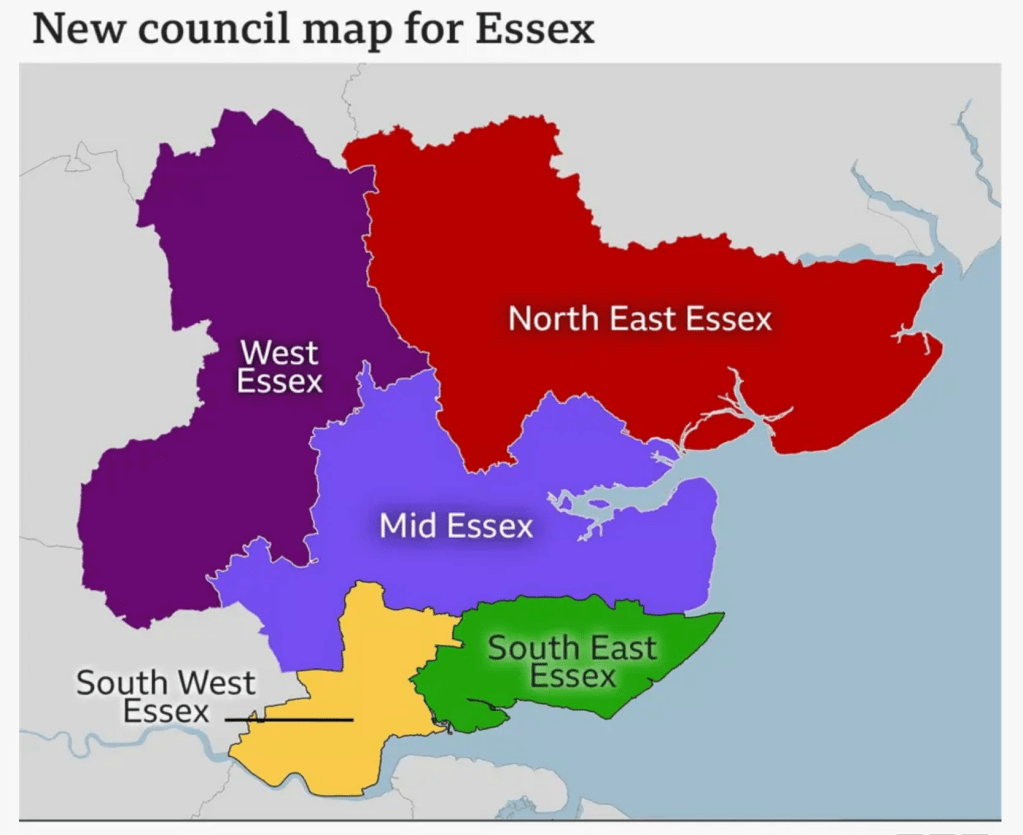
The five authority model was the one favoured by most existing authorities and does not centralise powers as much as the three model. It is still a centralisation however and decision making will move further away from the people it affects, while the case that the reorganisation will save money is surely weakened by choosing to have five rather than three.

Read more: Hostile Environment


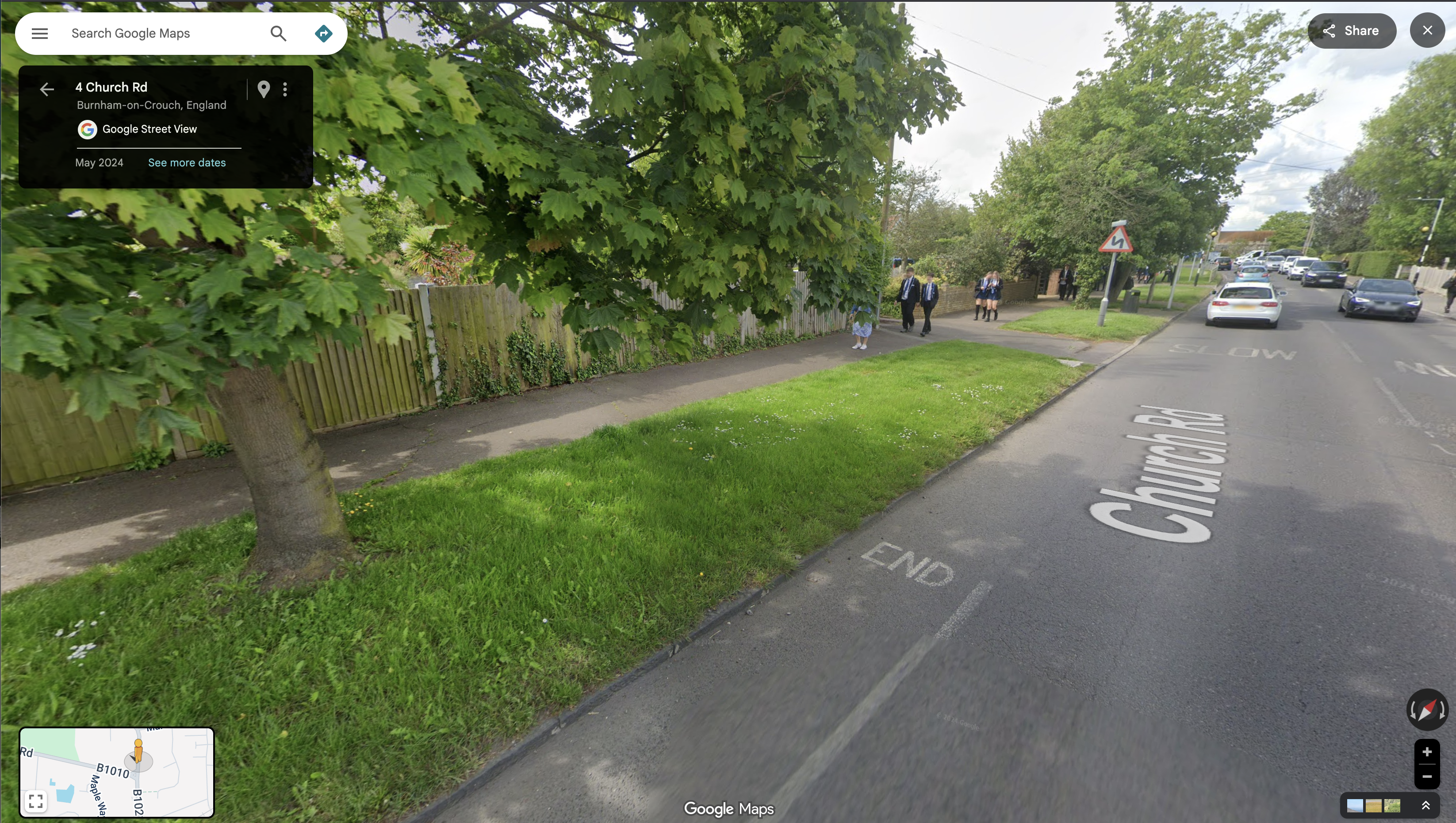
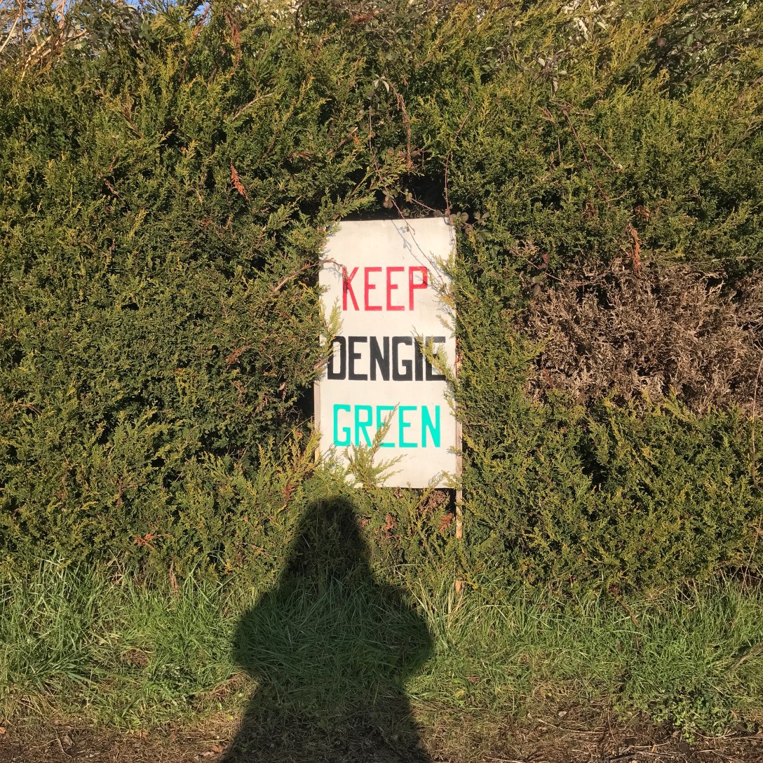
The Dengie will be in the ‘Mid Essex’ unitary – an authority that will stretch from the Greater London boundary to the North Sea coast. It seems likely that the seat of power will be in the City of Chelmsford. It’s the only city in the region, it’s fairly central geographically and it has the buildings and staff of the doomed Essex County Council to draw on, making a transition easier. For similar reasons, I imagine that Chelmsford will also be the seat of the Greater Essex Mayoral Authority when an Essex Mayor is elected in May 2028.


(this all presupposes that a General Election doesn’t happen before local government reorganisation and the Mayoral election and that the next government doesn’t cancel the whole thing as a Starmer folly. Reform UK leader Nigel Farage has said he is “deeply sceptical” about changes to local councils in Essex, “I think that to maintain overall the presence of an identifiable county council is the right way to go” and that Reform UK would try to put a stop to local government reform).

Design and Climate Change section of the Maldon District Local Development Plan


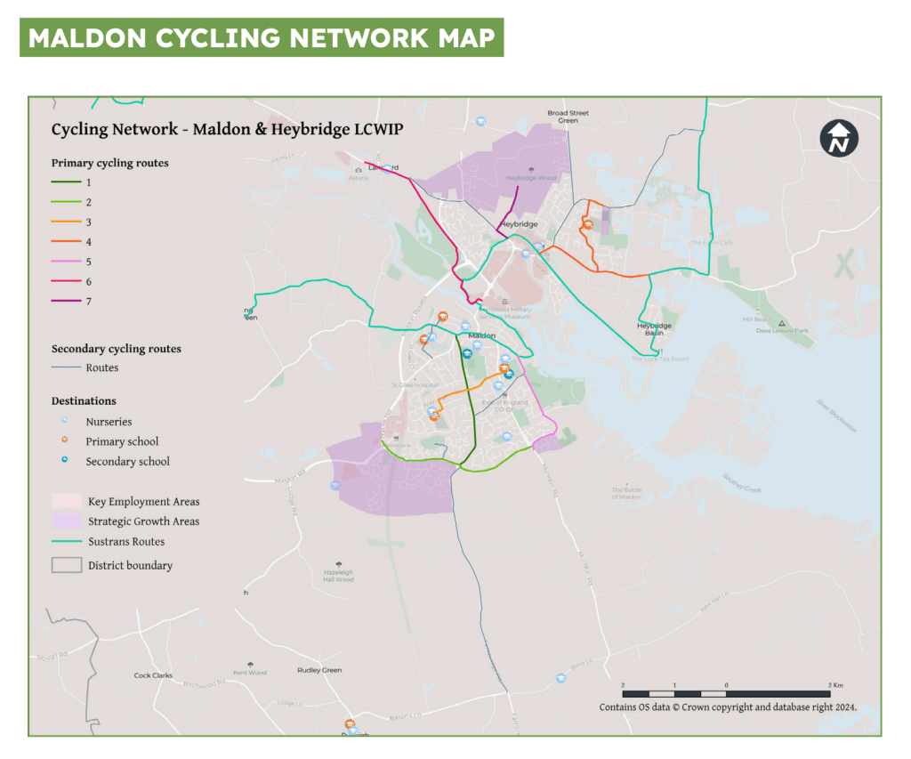
For the Dengie, a move of powers from Maldon to Chelmsford means authority moving from a town it abuts to one that is further away. It’s unclear what value strategies developed at Maldon District level will have when Maldon District is no more – not least the Maldon District Local Development Plan 2014-2029 (reviewed Feb 2025), more recent Neighbourhood Plans across the district that are constrained by the LDP, and the Maldon District Council’s Climate Strategy and Action Plan [pdf].

https://www.carbonbrief.org/ccc-cut-uk-emissions-61-by-2030-for-fifth-carbon-budget/


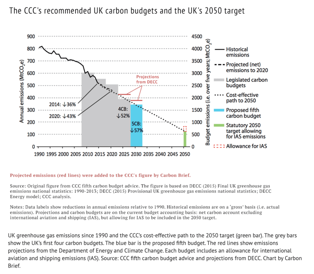
We are entering a crucial period for achieving the UK’s legally binding target of net zero greenhouse gas emissions by 2050 and the interim target of a 58% reduction by the period 2028-2032.

This uncertainty at District level is multiplied at County level. Essex County Council, under a Conservative Party administration, has developed a raft of climate and environment strategies and policies which say a lot of the right things, even though delivery has often been frustratingly slow.

Net Zero: Making Essex Carbon Neutral [pdf]


That lack of speed may prove fatal if the political character of the local authorities changes to one less enamoured of net-zero and climate goals. The current polling is therefore sobering.

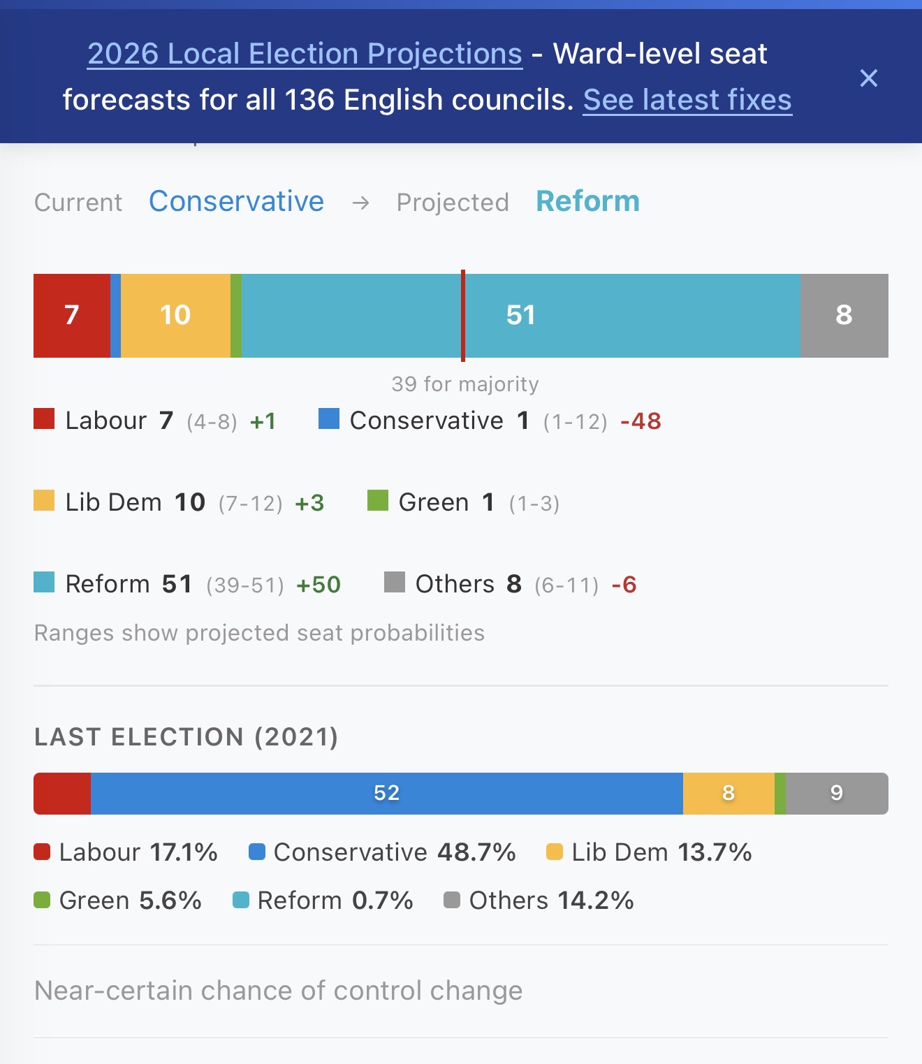
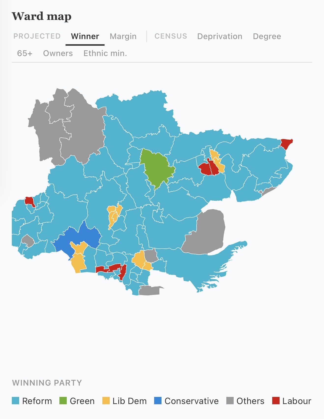
https://www.pollcheck.co.uk/council-projections/essex/#/essex


With a few weeks to go, the Conservatives look set to be wiped out at the May County Council elections. Even the low end of projections for Reform UK would give them majority control in Essex. Conservative Party ‘Climate Czar’ Councillor Peter Schwier is one of those who looks set to lose his seat to Reform UK.

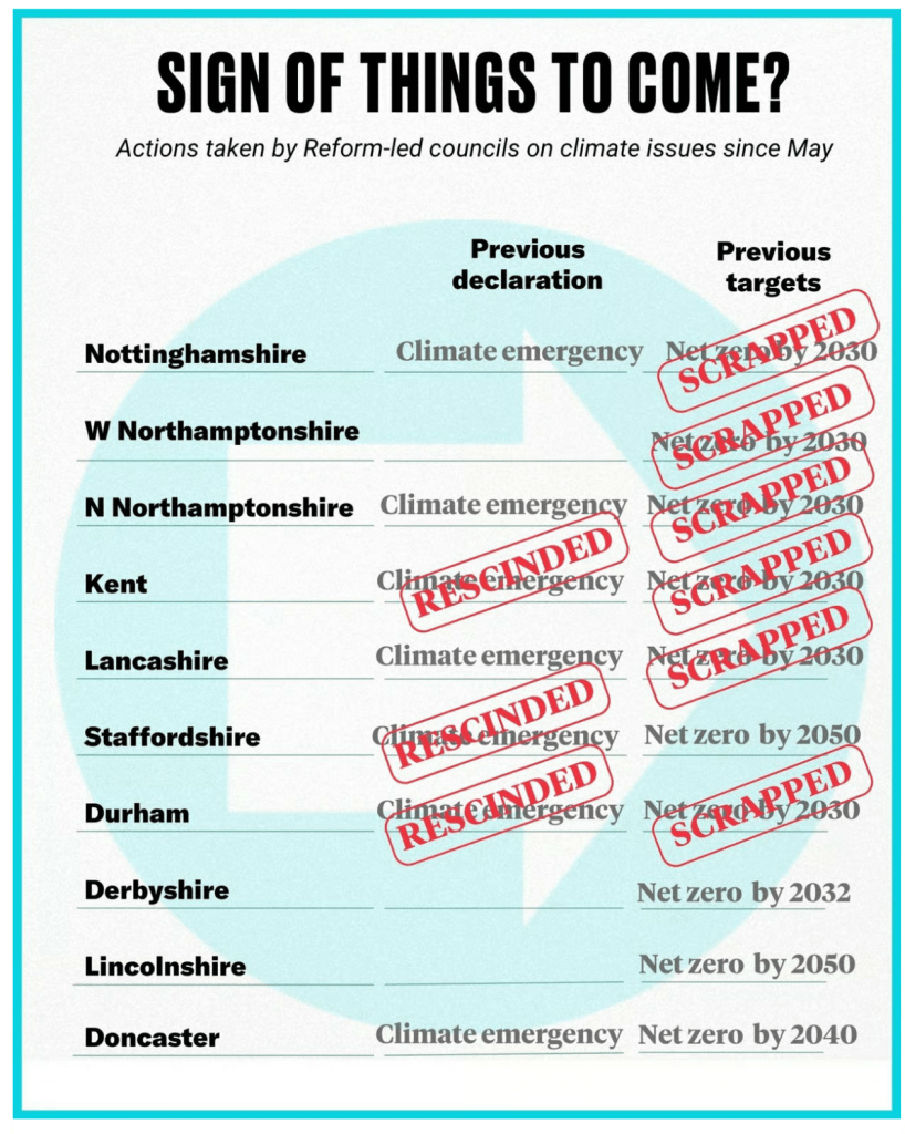
What happened across the Thames at Kent County Council (KCC) when Reform UK took control is a guide as to what to expect: the party initiated sweeping reversals of previous climate commitments.

• Reform UK councillors rescinded KCC’s 2019 Climate Emergency Declaration
• The Reform-led council removed Net Zero/carbon neutrality targets and abandoned efforts to meet those targets previously set by the council.
• Background information provided by the Reform UK group said the council’s 2019 climate emergency declaration had “endorsed the unproven view of anthropogenic (human-induced) climate change” [pdf].
• They cancelled £32 million of renewable energy property modifications.
• They cancelled £7.5 million of electric vehicle transition plans
• They voted down motions aimed at supporting the recovery and growth of wildlife and biodiversity by reducing harmful pesticides – despite environmental and public‑health concerns.
• Reform UK councillor Chris Hespe called anthropogenic global warming a “hoax”.
• Reform UK councillor David Wimble shared a Facebook post highlighting a “Climate Catastrophe Hoax”, where “the climate apocalypse narrative is exaggerated, wrong, and built on fear rather than fact”
• Seven out of ten Reform UK controlled councils have scrapped their climate targets since being elected
• Academic analysis from the Grantham Research Institute (LSE) found that Reform‑run councils “removed content about climate change from strategy documents” after taking control. KCC is explicitly listed among the councils where Reform UK councillors expressed climate‑science denial and participated in these removals [pdf].

Reform’s local councils are bringing climate denial into the mainstream

Strategies and policies are much easier to reverse than already existing actions on the ground. I can’t help but think that much of the last decade was wasted and all the pretty pdfs and consultations produced are now dead in the water. Essex should have taken direct control of buses and integrated public transport ticketing and timetables, planning authorities should have demanded net-zero, low bills, homes with domestic energy generation, rain/grey water recycling and minimum 30% on-site biodiversity net gain, the county should be laced with segregated walk/wheel/cycle paths breaking car dependency and improving health outcomes, money spent on waste incinerators should have been burned creating a circular economy instead, our anchor institutions should have collaborated and built community wealth via local procurement led by the public authorities.

Peter Harris, the Reform UK mayoral candidate for Essex, hasn’t yet made any statements specifically about environmental issues such as climate change, net‑zero, renewable energy, pollution, or biodiversity. He has mentioned ‘protecting our green spaces’ as part of a very general policy agenda, but there’s no detail on what this means in practice.


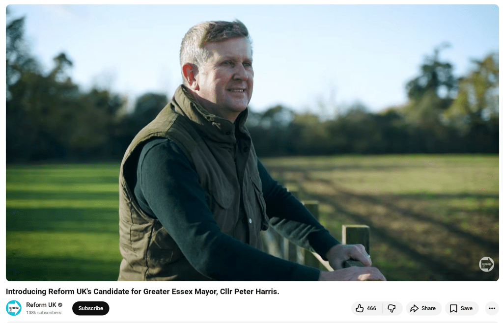
His promo video has him stood in some fields and his comments there seem to position the ‘green spaces’ protection as being about housing developments rather than nature recovery or habitat protection.

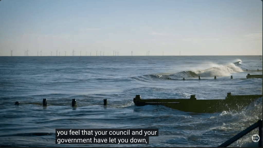
There’s a brief shot of the tide coming in on the Essex coast with the Gunfleet Sands Offshore Wind Farm visible in the distance – but there’s no mention of sea-level rise or renewable energy. Over this image, Harris is talking about the council and the government ‘letting you down’ – is the tide and the wind farm relevant to this, or just B-roll? Hard to tell.


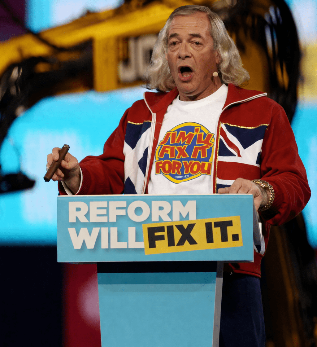
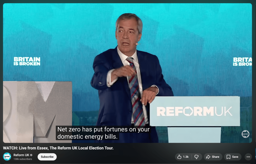
Last week, The Reform UK Local Election Tour, obliviously called ‘Reform will Fix It’, visited the Circus Tavern in Purfleet, Essex. Following some chat with former glamour model Jodie ‘#frippsfarce’ Marsh and Cllr Jaymey ‘bankrupt / ‘unsolicited private parts’ McIvor, and a warm-up from David ‘ONLY Reform UK will scrap the insane Net Zero targets’ Bull, it was on to Zia “If there’s one thing [the UK] is not under threat from, it’s climate change” Yusef, and Nigel “I haven’t got a clue whether climate change is being driven by carbon-dioxide emissions” Farage.

Dr David Bull
Nigel Farage stand-up set at the Circus Tavern

With the Earth’s climate further out of balance than at any time in recorded history, the crash in wildlife populations constituting an extinction event, and human activities increasingly disrupting the natural equilibrium, creating consequences for hundreds and thousands of years, the return of climate change denialism is a bitter pill to swallow.

This week The Times reported that it had seen a document called ‘Status of Defra’s critical systems to 2030 and beyond’, commissioned before the 2024 election by civil servants at the Department for Environment, Farming and Rural Affairs (Defra).

Tasked with identifying looming threats to the underpinnings of modern life, its authors in the Defra Futures team, an expert group of civil servants, concluded that not only Britain’s food supply but also its water supply and international trade networks were “almost certain” to be “on a decline and collapse trajectory”, meaning there was “a realistic possibility that by 2030 (increasing to 2050) our food, water and natural ecosystems (etc) are at strategic risk of catastrophic failure”.’

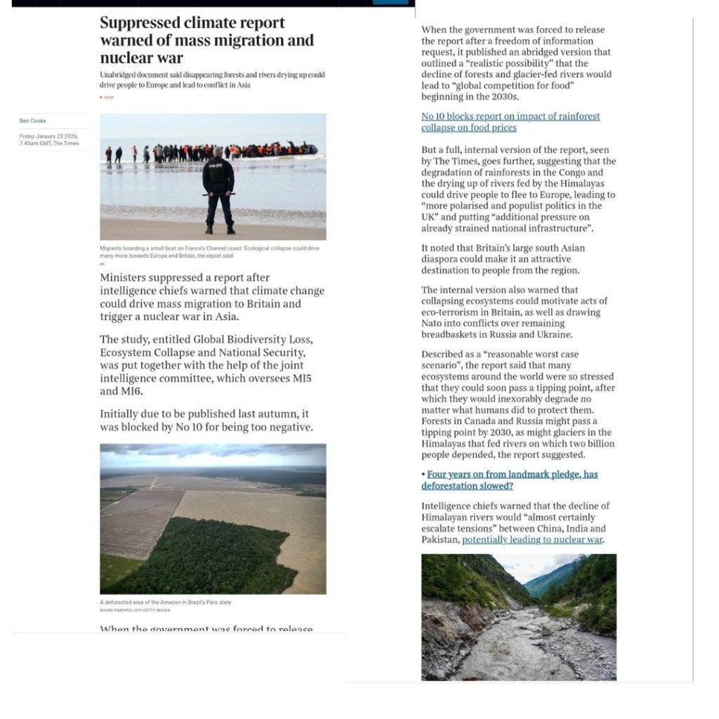
The Government denies a document with this name exists, but a couple of months previously, The Times reported on a different study ‘Global Biodiversity Loss, Ecosystem Collapse and National Security‘ put together by the joint intelligence committee (which oversees MI5 and MI6). Due to be published last Autumn, it was suppressed until an FOI request produced an abridged version.

From the abridged ‘Global Biodiversity Loss, Ecosystem Collapse and National Security’

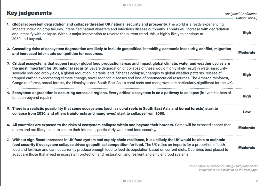
The Times reports that it has seen the unabridged version which paints an even gloomier picture of how climate change might affect the UK: driving mass migration from parts of the world made uninhabitable, provoking wars and acts of terror, and creating a global competition for food.

It looks like those of us working to address the climate and ecological emergencies are about to encounter a hostile political environment. When I directed my energies into working with a local climate action group (which was encouraged into existence by the local district council), I did so because I saw opportunities for genuine positive change afforded by the commitments and strategies agreed at political levels from the national to the parish. If, and when, those commitments are abandoned, those strategies are shredded, targets are scrapped, and actions to address the climate and ecological emergencies are ditched – the way forward is unclear. These are the conditions that often produce climate despair and depression, a fatalistic surrender to personal consumption and hedonism, or moves towards more confrontational approaches and direct action.


The Essex-wide LCWIP

Like me, many of you may have responded to the Essex County Council consultation on the ‘Essex Wide Walking and Cycling Infrastructure Plan’. The results of that consultation were quietly released last August (2025), so you may not have seen them. I’m still working through the documents and I welcome comment and feedback from anyone else who braves them!

[As a reminder, settlements of 20k+ population each got their own Local Cycling and Walking Infrastructure Plan (LCWIP) while everywhere else in Essex was covered by the ‘Essex Wide’ plan. As no settlement on the Dengie reached the 20k threshold, the entire peninsula is covered by that plan. Maldon & Heybridge’s population combined exceeds 20K so they have a separate LCWIP. One of the maps in that document indicates a ‘secondary cycle route’ from Maldon into the Dengie using the B1010/Fambridge Road and ending abruptly at the Baron’s Lane junction]


The Consultation response consists of three documents :

  1. A Summary Report [pdf]
  2. A Consultation Report [pdf]
  3. A Technical Report [pdf]
Read more: The Essex-wide LCWIP

Al of these can be accessed here

  1. The Summary Report is not particularly informative. It contains a timeline of three steps which ends with ‘Autumn/Winter 2025/2026 Development of pipeline of infrastructure schemes’ – we are in the last weeks of that period now but I can find no further information on these infrastructure schemes.

  2. If you commented on the consultation, you should find your remarks reflected in the Consultation Report (the Dengie is poorly represented in the maps included in this document with just a glimpse of the south of the peninsula to the top of the South Essex Map)

  3. The most interesting of the three documents is the Technical Report which includes new maps identifying potential key walking and cycling networks which I share below, with zoomed in images of the Dengie.

The ‘route proposals’ in the Final Network Plans look identical to those in the Consultation document however, they don’t reflect these key walking and cycling networks, and they follow existing roads without a clear sense of how walking and cycling will be made safe on these highways.

The Technical report notes that:

‘Given the rural nature of the area [Essex], the plan prioritises cross-boundary connections between towns and cities, utilising off-road routes like Public Rights of Way (PROWs) and bridleways, and innovative on-road cycling solutions in constrained networks.‘

The Summary Report expands this slightly in it’s introduction:

‘Given the mainly rural nature of Essex, the Essex-wide plan prioritises links between villages, towns and cities. The proposals aim to make use of off-road routes such as byways and bridleways, alongside innovative on-road cycling solutions on space-limited networks such as quiet lanes to deliver the LCWIPs.’

The nod to rural areas is appreciated but I’m dismayed that the strategy seems to depend on:

  1. existing byways (there are 3 on the Dengie totalling 2714m in length)
  2. existing bridleways (there are 8 on the Dengie totalling 9,178m in length)
  3. existing ‘quiet lanes’ (there are none designated in Maldon District totalling 0m in length)

That’s a total of a bit over 7 miles of ways that already exist and that we know are not fit to provide a continuous cycling route – they are isolated, dispersed, poorly connected and provide no east-west connections. I haven’t yet found any reference to improvement works on these already existing paths, so its unclear what the consultation/strategy/plans have added to the status quo.

It may be that the plan is for new off-road routes, new byways, bridleways and quiet lanes – which would be great! I haven’t found any hint of that in the documents yet though.

You’ll also have noted that the walking and cycling plans often seem to just talk about cycling. New cycling routes would also increase capacity for those walking and wheeling but it would be good to see some more reference to the particular needs of all active transport users in these reports

The Technical Report prepared by consultants WSP has a photograph on its first page of a rural cycle path, with a bike propped up against a smart wayfinding post which immediately had me wondering where in Essex this was, as I haven’t seen anything like it in the county before. I zoomed in to see more detail – at the top there’s a logo and text for the ‘Essex Region Conservation Authority’, neither of which I recognise, and the phrase ‘Essex Region’ sounds off. Below this are some co-ordinates that seem off too and a distance marker to somewhere called McGregor. The final square on the post has a person with a rifle on it and the legend ‘No Hunting’.

If you hadn’t guessed it yet, this photograph isn’t from the English county of Essex, it’s from 6000km away in Essex County, Ontario, Canada – close to the motor city of Detroit. It’s a photo on the Chrysler Greenway, a 50-kilometre nature trail that comprises the southernmost link of the Trans Canada Trail – at 28,000 km (17,000 mi) the longest recreational, multi-use trail network in the world.

I trust that this indicates the scale and ambition of Essex County Council’s plans rather than a stock photography fail by a WSP intern and I look forward to the Autumn/Winter 2025/2026 announcement of the infrastructure schemes to make it happen!

Stitching the Path: Connecting Disjointed Walk & Cycle Routes 1

A mission objective of the rECOnnect Dengie project is to improve the active travel infrastructure on the Dengie and get a safe network of routes connecting all the settlements. As I’ve noted previously, there are lots of good words about achieving this sort of thing in the strategy documents produced from the national level down to the parish – but what happens next? How does it happen?

This in the first in a series of posts where I’ll look at where there are opportunities on the Dengie to connect up existing routes and how we might turn document objectives into objective fact. I’m starting close to home in Burnham-on-Crouch.

The Burnham-on-Crouch Neighbourhood Development Plan [pdf](2017) expressed a clear desire for better active travel infrastructure:

5.3 Make Burnham-on-Crouch a More Pedestrian and Cycle Friendly Place to Live

The Town should have a friendlier environment for cycling and walking. Its main and secondary roads are dominated by vehicles. New pedestrian and cycle routes should be provided that link the town centre with existing and new neighbourhoods, schools and recreation areas via quieter roads.’

It substantiates this objective with policies including:

One of the first new neighbourhoods created after the NDP is the Grangewood Park estate which was built on agricultural land allocated for new housing as Site S2 (j) in the Maldon District Local Development Plan [pdf]. A site with a long southern boundary to the town’s Secondary School, the Ormiston Rivers Academy.

Figure 12 in the Burnham NDP (Apologies for poor image quality, this is as it appears online)

The masterplan [pdf] presented by developers Charles Church in their planning application included a new off-road foot/cycle path running through the green space on the estate and providing a connection from Southminster Road in the east to Green Lane in the north.

Their document notes that the Maldon LDP includes:

T2 Transport Infrastructure in New Developments The layout of new developments should provide for safe access to and from the highway including… links to adjacent or nearby foot/cycle path network’

and that it states that amongst the criteria any proposed development must satisfy is:

‘Safe pedestrian and cycle linkages are provided from the development to the town centre, other public service facilities and the existing urban area’.

(The Residential Travel Plan [pdf] supplied in the developer’s application noted that ‘[t]here are no dedicated cycle facilities in the vicinity of the development site’)

Later the planning application notes that ‘[t]he Burnham Neighbourhood Plan shows proposed cycle links that the Town would like to see progressed; within this diagram a possible link is shown into the site subject to this application. The provision of this link would rely on third party land and therefore cannot be provided by Charles Church, however the scheme has been developed to facilitate future connectivity.’

It’s unclear exactly what this is referring to, as the Burnham NDP includes text references to possible cycle routes but no maps showing these. The diagram with ‘a possible link’ is perhaps the green dotted line ‘new pedestrian route’ shown in the NDP’s ‘Figure 12’ (copied above) connecting the site to Maldon Road in the south, and running along the western boundary of Ormiston Rivers’s playing fields. This would have been a convenient addition to Burnham’s walk/wheel/cycle routes but it never materialised and it illustrates succinctly a key unaddressed problem in getting better active travel infrastructure.

i.e A government strategy proposes active travel infrastructure as an essential part of new developments, a developer provides infrastructure within the development – but the value of such infrastructure is largely produced by a larger connectivity that neither government nor developer is providing.

The National Planning Policy Framework (NPPF) make enough noises about pedestrian and cycle routes that applications for new housing tend to include vague promises about including them. On the ground this tends to result in intra-estate pathways that have genuine utility but terminate at the estates’ boundaries with no clear sense of how onward travel on foot, mobility device or bicycle might proceed.

Foot/cycle paths shown in grey to the north of the housing on Grangewood Park estate

True to their promise, the developers of Grangewood Park delivered the walk/cycle path on their masterplan and the estate includes what is, currently, the best example of active travel infrastructure in the town with an off-road path that connects Southminster Road with Green Lane – but what happens when you get to Southminster Road or Green Lane? What contribution does it make to a safe, active travel network?

At Southminster Road (B1021) the pathway ends 160 metres north of the entrance to Ormiston Rivers school. A child on a bicycle coming through Grangewood Park must now leave the off-road cycle path, cross a lane of northbound traffic leaving town on the B1021, and join the southbound lane – before turning across the path of northbound traffic again to complete their journey to school. Opposite the Grangewood junction there’s a road sign with the red triangle warning of a school ahead and, beneath it, one of those advisory-only ’20’s Plenty’ signs – but the B1021 has a 30mph speed limit at this point and has limited direct access along this section, a form that tends to encourage vehicle speeds in excess of the legal limit. The common experience of cyclists, of all ages, using this road is driver impatience and an aggressive eagerness to pass.

Meanwhile, pedestrians leaving the off-road path at Southminster Road find there is no footway providing an onward walking route north or south. There is a narrow pavement on the east side of Southminster Road but there is no controlled crossing to reach it (a small traffic island provides some pedestrian refuge).

School children cross the B1021 to reach the Grangewood Park Estate.
The junction of Grangewood Park Avenue and Southminster Road, where the foot/cycle path ends

Once the road is crossed, a pedestrian can proceed south on pavement into Burnham. If it’s a child walking to the school they can pass the school entrance on the other side of the road and carry on further south around a bend to cross the road at a zebra crossing, then walk north again up the opposite pavement to reach the school entrance – a distance of 450m. Will they do that though? Of course not!, once they are opposite the school entrance our cyclist used – 160m down, they’ll do what she did and cross the road there. The curve of the road means that drivers travelling south will be blind to a child crossing the road there until they are quite close. The Highway Code calculates the stopping distance of an average car at 30mph in dry conditions to be 23 metres.

Looking north up Southminster Road where a child is liable to cross to reach the school
Car stopping distances in the Highway Code

‘But there’s no alternative!’ I hear you cry, ‘you just have to make do with what you’ve got’.

‘I know this estate is right next to the secondary school and we agreed in the neighbourhood plan to “plan, build and highlight clearly signposted, direct and safe cycle and pedestrian routes into the Town from new and existing neighbourhoods, between all schools and the town centre” and we agreed that we would “improve the pedestrian and cycle journeys to/from each of the schools” – but really what else could we have done?

Let me tell you!

Grangewood Park shares a border with Ormiston Rivers school, their frontage to Southminster Road is contiguous. The foot/cycle path could have gone over Grangewood Park Avenue and continued south over amenity land to the boundary of the school and through the small woodland which separates it from the paved area of the school grounds.

The red line indicates where the Grangewood path could be connected to Ormiston school, the blue line how that could continue to the existing footway

All the land involved either belongs to the developer or to Essex County Council. The developer was on-board with facilitating connectivity, the Town and District Councils wanted connectivity, Essex County Council/Essex Highways wants kids to cycle to school. It should have happened… and it still can!

The current residents of the three houses on Grangewood Park estate facing Southminster Road might prefer the current area of mown grass and small flower bed, but they’d benefit from a walk/cycle/wheel route through it. Improving active travel routes is beneficial for everyone, not just children.

This missing link would facilitate footway access from Burnham’s riverside, urban centre and railway station through to Green Lane by reducing the number of necessary road crossings. It would complete a safe cycle route from the Grangewood Park estate to Ormiston school.

EXTRA CREDIT: The pavement going south from Ormiston School has an area of verge and is wide enough to allow a shared foot/cycle way to the junction with Maldon Road (B1010). Across the B1010 junction, in the northbound lane, there is also Burnham’s oldest piece of cycling infrastructure – a painted cycle lane that begins just south of it and finishes quickly north of it – it’s of spurious utility but nevertheless could easily merge into a cycleway on the west of Southminster Road and gain a connectivity it has never had before!

What happens at the other end of the Grangewood Park estate foot/cycle path though? Can we get anywhere from there? Look out for Stitching the Path: Connecting Disjointed Walk & Cycle Routes 2 – where I will address these very questions!

Why Don’t We Do It in the Road?

A couple of days ago, Essex Highways released a press release about their plans for rolling out electric vehicle charging in the county, and used the opportunity to ask people where they thought the chargers should go. Their survey is pretty minimal, but there was enough in it to raise my concern.

I’ve long been frustrated by the pavement parking of cars and how temporary road signs are placed on the footway rather than on the road they relate to. Cars already dominate urban space. In the rural town where I live, especially in the older parts built before the automobile, the streets are cluttered with private vehicles. The nearest pavement to my house is unusable – cars park on its full width to allow free access to vehicles on the road, so pedestrians have to walk on the road too. One of my neighbours has an EV, and the charging cable stretches from his boundary wall across the street to his car.

There’s a sci-fi saw, often attributed to Frederik Pohl, that ‘a good science fiction story should be able to predict not the automobile but the traffic jam’. You don’t have to be a futurist to see the trip hazard in the electric car rollout. Motornormativity —the assumption that car-centric infrastructure is the default—demands that any new space requirements for the automobile be carved from the realm beyond the car. When Essex Highways asked ‘where should the chargers go?’, the assumption is clearly that the person being asked is a motorist, an EV owner seeking on-street charging for their machine. The ‘where’ is not ‘where in the public realm, if anywhere, should we put this new chunk of motorcar infrastructure’, but ‘which streets shall we impose this pile of gubbins in?

Continue reading “Why Don’t We Do It in the Road?”

Weeknotes 02025 Q1 W6

Over the weekend we received the disappointing news from Essex County Council that they were unwilling to let the Burnham Library Orchard project go ahead, with some not very detailed reasons about ‘infrastructure’ which seem to pertain to the library building itself which would have been unaffected by the proposal.

Burnham-on-Crouch Library

Tuesday. The Dengie Hundred Bus Users Group (DHBUG) monthly meeting. Hints that the D1 bus might be under threat of being withdrawn now, another hit to Dengie services.

Wednesday – I signed some documents as part of the process of formally registering eMpower Maldon as a Community Benefit Society. John Philpot’s done most of the admin work getting us to this point. We should be registered before the Community Led Energy Planning meeting in Maldon town in March.

Continue reading “Weeknotes 02025 Q1 W6”

Weeknotes 02025 Q1 W5

DCAP

We had our monthly meeting on Thursday and tried to do some Thermal Imaging of 4 homes at the same time – which was ambitious. The only way to make it work was to split the group in two and I wasn’t really happy with things working out that way. Earlier in the week I spent some time looking through Parish Plans and Neighbourhood Development Plans from across the Dengie looking for opportunities and commitments.

Jo Coombes and I have been working on an idea I’m tentatively calling ‘Looking out for Nature’ inspired by the work that Wild Justice did identifying that ‘Nearly half of the nature-friendly enhancements promised by developers building new homes have failed to materialise’. I shared this report on local social media and suggested that because Maldon District Council has no professional ecologists on staff it was in high peril of developers not fulfilling their legal biodiversity commitments. I got a comment that ‘MDC Planning employs Planning Enforcement Officers who are responsible for investigating developments where planning has not been granted and checking that planning conditions attached to planning approvals have actually been carried out. Where a condition regarding trees or bird box has been inserted then they would check the compliance’ with a link to the Planning Enforcement. If you actually look at the Planning Enforcement site though it doesn’t support the claim that Planning Enforcement are proactive and makes checks. ‘ Their own overview description of their work simply states: ‘The planning enforcement team has responsibility for investigating complaints [my emphasis] principally where unauthorised development has taken place and aims to resolve these using the most appropriate means.’ i.e. they are reactive. It’s impossible to see how planning authorities like Maldon will be able to assess whether developments meet the 10% biodiversity gain

This places the responsibility to identify breaches with concerned citizens, hence the project. Do we really have the capacity to do it though?

Continue reading “Weeknotes 02025 Q1 W5”

Park It

Maldon District Council (MDC) is considering charging for the car parks in Burnham-on-Crouch. Some people are annoyed and have started a petition against charging, including friends and people I know. The Town Council has posted a notice promoting the petition on its official noticeboards and some councillors have announced their support for the petition. I take a different position.

Continue reading “Park It”

The Reformation

Thursday 5th December was the deadline for electors to request a ballot to fill the empty seats on Burnham-on-Crouch Town Council (BTC). I’ve seen a couple of people online saying they would be requesting one for the sake of democracy and to avoid the remaining councillors co-opting whoever they please. There’s still no news about the result and whether elections will be forthcoming. I suspect enough folk will have asked for an election to get one, but not enough people will stand for there to be a contest—certainly in the North Ward.

Continue reading “The Reformation”

Year One

Last week, we celebrated the first year of the Dengie Climate Action Partnership (DCAP) with a social at the Victoria Inn.

More folk turned up for the social in the pub than regularly do for the monthly meet-ups in Burnham Council Chamber. An unsurprising but salutary reminder that an open formal meeting is not for everyone.

Continue reading “Year One”

Get on the Magic Bus

Today was supposed to be day one of the new 45 bus service on the Dengie. This would replace the D4 and Dart 5 with a much-reduced timetable combining those two buses. The scheduled services would be reduced to two a day in either direction, Monday to Friday, with the Saturday service lost entirely. The Dengie Hundred Bus Users Group (DHBUG) had intervened to tweak the timetable in Essex County Council [ECC]’s tender as the original proposal gave little time at the route’s destination before returning. As many users depended on the bus to do their weekly shop they would have found themselves with less than an hour to do so. At the DHBUG AGM on 7 June, many attendees were furious about the changes and reduction in service – but ECC didn’t send anyone to the meeting and Arrow Taxis who had won the tender sent a message saying that it wasn’t worth them coming as they didn’t know anything about what was going on past what had been published already.

Continue reading “Get on the Magic Bus”