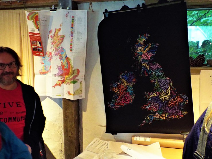
Your humble correspondent setting up with a BGS geology map and Robert Szucs’s river basin map [photo courtesy of Alan Charlton]Ed Tyler and I delivered a workshop on Bioregional thinking at the 2018 National Permaculture Convergence, which took place in Hulme, Manchester last weekend. The session was well attended and enthusiastically received which was a relief after all the stressing out and prep I did beforehand. I didn’t manage to cover everything I wanted to include, so the slideshow linked to here Continue reading “National Permaculture Convergence 2018”→
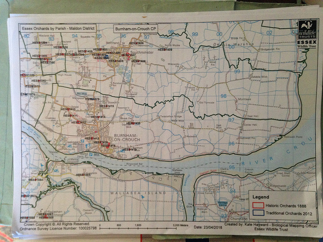
I have just signed up as a volunteer on the Orchards East project – I will be researching the history of orchards in my local parish of Burnham-on-Crouch.
Orchards East Survey Map
I’ve been provided with an OS map of the parish marked with the locations of orchards identified on the c.1888 ordnance survey map. My first task is to survey those sites for any extant orchards or what has replaced them. I’m beginning with the site nearest to my house, which has been designated HESS1416. Continue reading “Orchards East”→
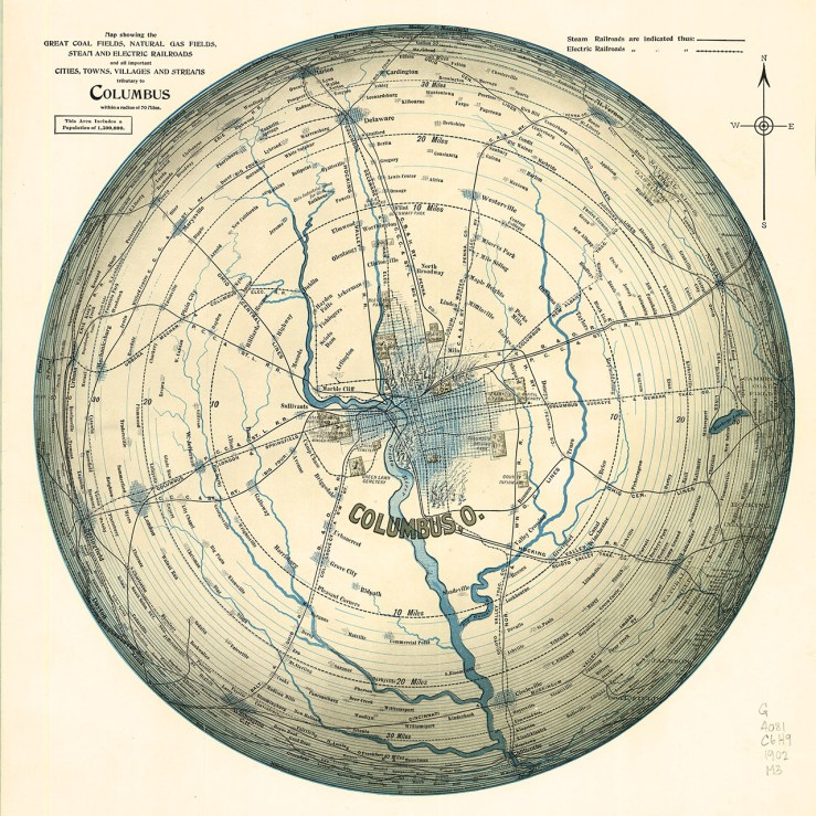
Azimuthal Projections is not a progressive rock album but ‘a map projection in which a region of the earth is projected on to a plane tangential to the surface, usually at a pole or the equator.’ I just came across (via Transit Maps) this azimuthal equidistant projection of Columbus, Ohio, USA which is catchily titled: Continue reading “Azimuthal Projections, RetroSuburbia & Solarpunk”→
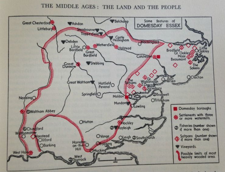
A rainy Easter Monday, but Burnham & District Museum reopened Good Friday for its 2018 season so I went there to renew my membership and review their library. The good selection of books there allowed me to do some more work researching the history of woodland cover on the Dengie. The Domesday Book period of 1086 CE and thereabouts gets the most attention as it remains the first substantive account of England. Several people have attempted to turn the records of the Domesday Book‘s purely textual account into a visual cartographic form – and one of the map elements frequently reasoned inductively is woodland cover.
Map from A.C. Edward’s A History of Essex; with Maps and Pictures (1962)
When it comes to catastrophic flooding in Essex 1953 tends to get all the coverage, but the inundation of 1897 was equally noteworthy – after breaches in the sea walls 30-35,000 acres of farmland were underwater. Eventually most of that land was re-claimed, but a stretch of the north bank of the Crouch, near North Fambridge, still reveals an area that was lost. Known locally as the horseshoes (not to be confused with the Three Horsehoes on Burnham Road) these artificial bays reflect the fall back defensive line that eventually became the de facto border between land and water when the original sea wall could not be rebuilt with the labour and resources available, The Google aerial view reveals something of the lost wall and lines of wooden stakes are visible at low tide marking where it would have been. Continue reading “Desk Research: Two Horseshoes”→
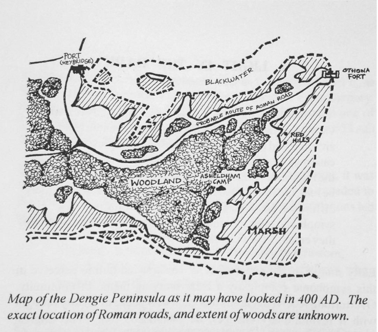
Illustration by Matthew Ayres from A Popular History of the Dengie Hundred
Mixed-bag of weather today that made walking far undesirable, especially after yesterday’s puddlicious Southend trip. Burnham’s little library has a small local history/topography collection with enough in it to hold one’s attention quite a while – including a copy of the book of the great Chapman/André 1777 map of Essex.
Another map has captured my imagination more recently however, the one above taken from A Popular History of the Dengie Hundred by M.J. Ayres, R.J. Blaney & T.J. Wood. This mapis a highly speculative rendering of how the Dengie might have looked in a period for which we have no good contemporary rendering. I’m attracted by the suggestion of woodland on the higher ground, as it gives some impression of what might have been lost locally (only 2% of Essex is covered by ancient, semi-natural woodland, Essex is the second least wooded county in England – and Maldon district has only 3% woodland cover of any kind), and because it visualizes a suggestion made by P.H. Reaney as to the etymology of the name Dengie itself: Continue reading “Desk Research: Dengie Woodland”→
From the cafe on the upper storey of the Antiques Centre in the old mill at Battlesbridge a view of the River Crouch. Battlesbridge is the head of the River Crouch navigation, the upper reach of the tidal zone and site of the most easterly bridge over the river. Geographically Battlesbridge sits at the south west corner of the Dengie peninsula.