[This article develops a recent Facebook post with more maps and discussion of cycle route potentials]
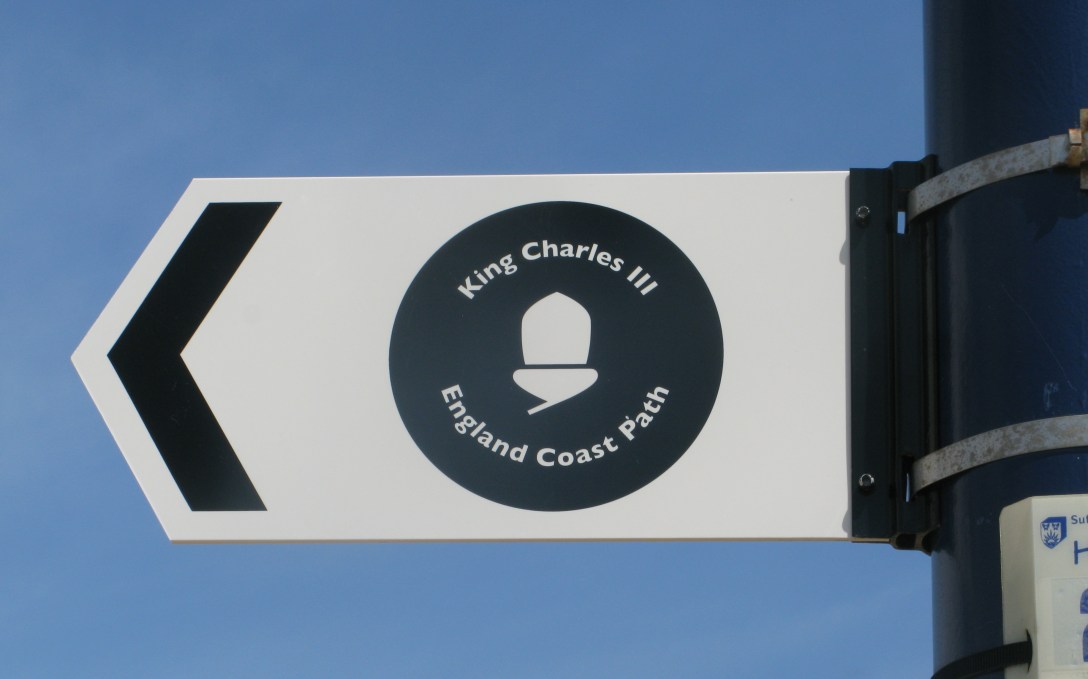
I received communication this week that ‘the King Charles III England Coast Path (KC3ECP), and its associated accessible coastal margin is now open around the full Dengie peninsula.’
There were some caveats in the communication, which I copy below
‘the King Charles III England Coast Path between Wallasea Island and Burnham-on-Crouch opened this morning.
Unfortunately with 2 weeks to go before the commencement date one of the contractors working for Essex County Council, on the north side of the Crouch, fell seriously ill. This has meant that although we continued with the commencement of the access rights, there may be a few pieces of infrastructure to finish off. Essex County Council are managing this as best as they can. It shouldn’t stop the onward journey, but under foot conditions may not be ideal at this point in time.
Now that the stretch is open, and in common with all other open stretched of the National Trail, responsibility for maintenance and related issues lies wholly with Essex County Council. If you ever have any concerns, I’d encourage you to reach out to Essex Council Highways/Rights of Way teams.’
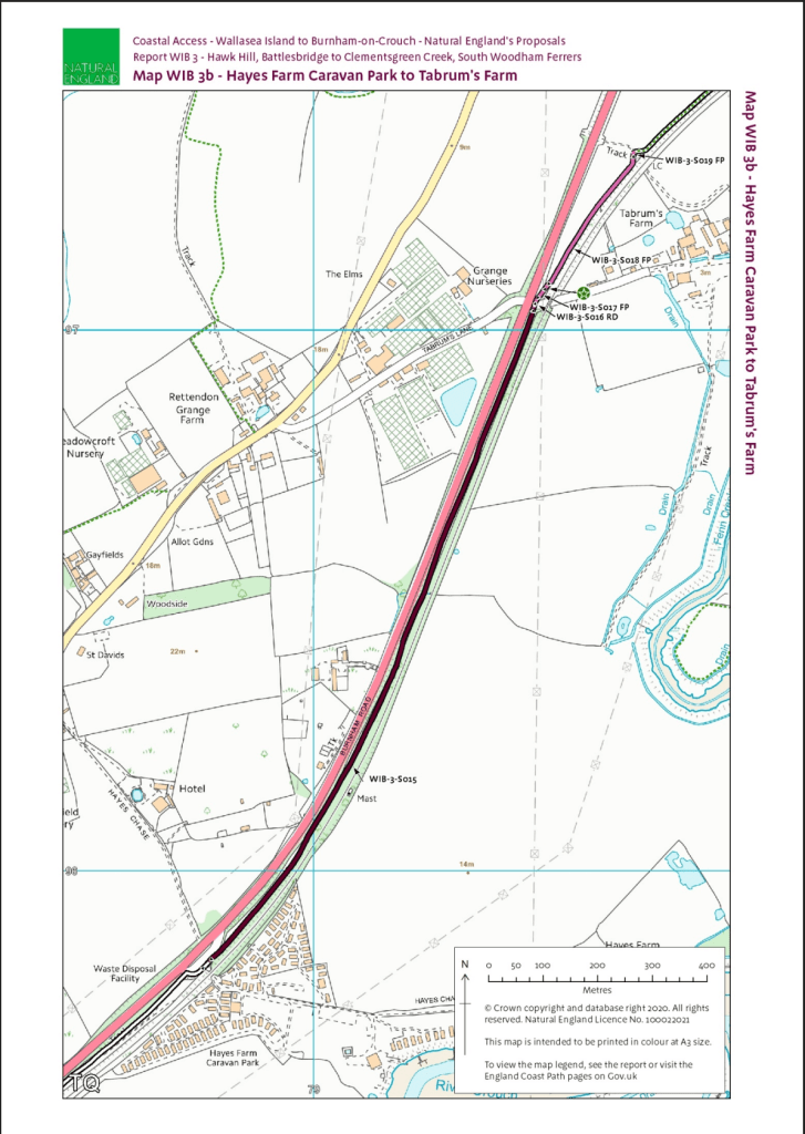
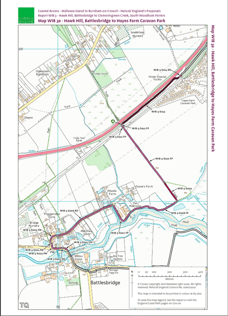
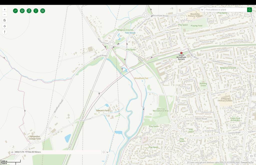
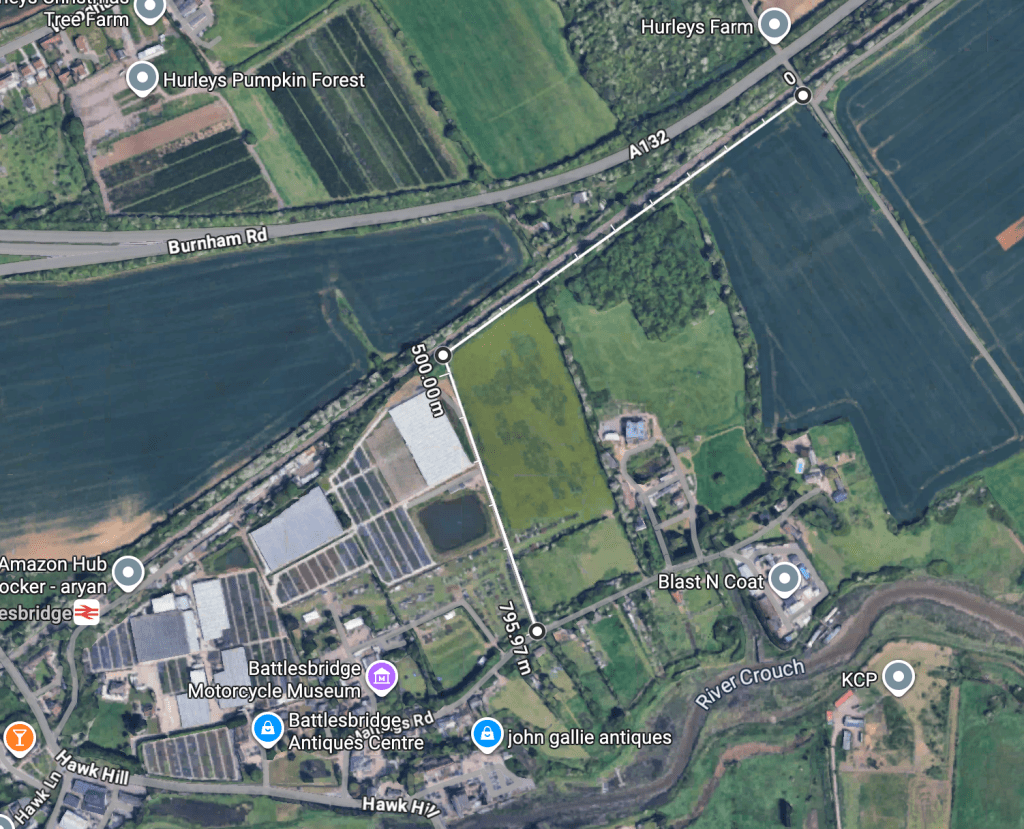
a path alongside the A132 Burnham Road connecting South Woodham Ferrers and Battlesbridge.
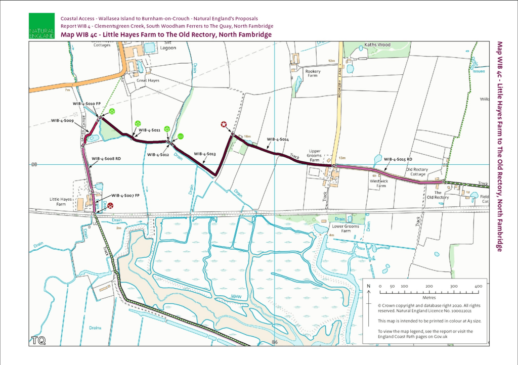
new permissions over a farm track between North Fambridge and Little Hayes Farm – allowing the route between North Fambridge and South Woodham Ferrers to avoid the long detour up around Stow Maries which involved crossing the B1012.
New KC3ECP route connecting with footpath FP 28 229 to the North, which leads toward South Woodham FerrersContinuation of the new KC3ECP path to where it meets footpath FP 27 229 providing access to BattlesbridgeNew section of KC3ECPpath/PROW on farm tracks connecting Rookery Land North Fambridge at Upper Grooms Farm with Little Hayes Chase and footpath FP 22 261 around Stow Creek.
I hadn’t seen much action on the A132 section last time I passed, so it might not be more than cutting foliage back on the verge. I’ll take a look at both the South Woodham Ferrers and North Fambridge this weekend, but I welcome comment from anyone else too!
UPDATE: I had confirmation from Natural England regarding the A132 section:
‘The major works undertaken along the sections WIB-3-S012 and S016 is the clearance of the vegetation and the creation of a route within the scrub, which I know has happened. There were some bridges and I believe some steps (at the S012 end) and these were being installed by the contractor that has fallen ill.
That said I believe the route is passable. I certainly managed to walk it this time last year in low walking boots and managed to pass without any bridges being in place.
I have previously discussed with colleagues at ECC that just clearing the scrub may not be sufficient and that there may need to be some form of surfacing (not metalled) if as I believe the enclosed nature means the ground lies wet for longer. The newly cleared areas will also encourage more vigorous side growth and spread of the likes of bramble and nettle. I encouraged them to consider seeding the length and then cutting it frequently (at least 4 times a year) to encourage a good grass cover but I don’t think this was undertaken. I hope they keep an eye on the condition of this section. It will not be Natural England’s responsibility to do so.’
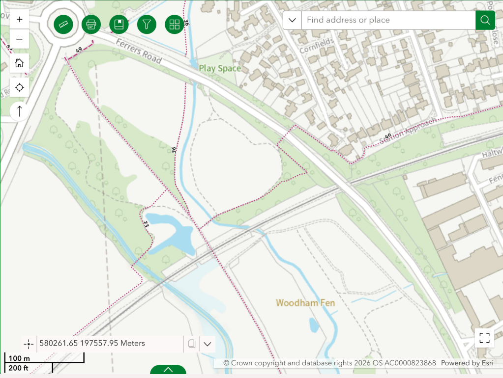
Improving the surface of A132 section to make it suitable for cycle traffic could provide part of a useful connector between the SWF/Dengie and the proposed National Cycle Route 135 at Battlesbridge.
If higher rights allowing bicycle use were allocated to footpaths FP 40 298 (772m), FP 23 298 (119 m), FP 28 229 (650m) and a short section of FP 35 298 (connecting FP 40 298 and FP 23 298) then South Woodham Ferrers, and its railway station, would have a safe, segregated, westward route out for cyclists (the footbridge in Woodhasm Fen might also need some adjustment).
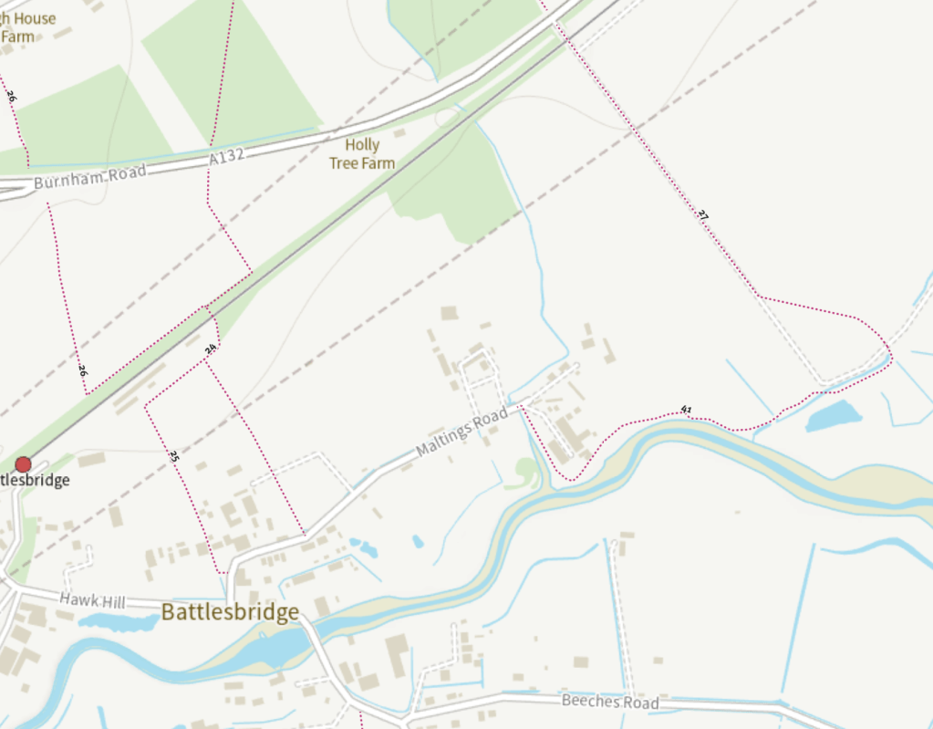
Similarly, where the new A132 path meets FP 27 229, some higher rights for bicycles on FP 27 229 (670) and FP 41 229 (654m) would provide access to Maltings Road, Battlesbridge allowing connection to the proposed National Cycle Network route 135 and Battlesbridge railway station at Hawk Hill.
Higher rights on specific footpaths to allow use bicycles, whether by upgrading to bridleways or otherwise, is one thing – but this doesn’t in itself ensure that the route is suitable for cycling. Soem surfacing work may also be necessary to achieve that.
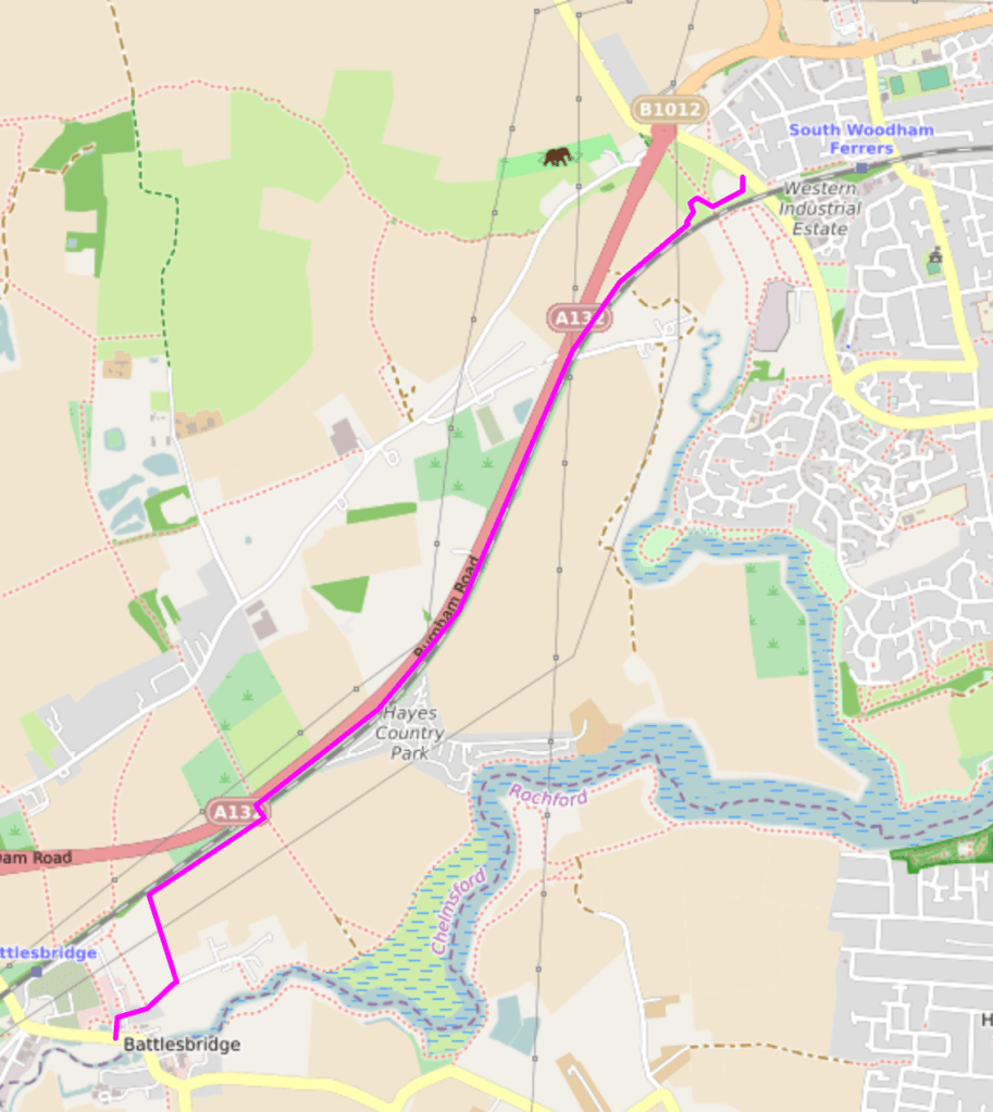
At the Battlesbridge end, I’m not convinced the footpath route described above is ideal. It would be better I think to create a new track, on Dons Farm land, from the bridge – parallel to the railway, before going South on the existing farm track to Maltings Road. Dons Farm belongs, I believe to DJ Fisher Farms.
Proposed new routefrom Bridge (803?) to Maltings RoadFull proposed route South Woodham Ferrers to Battlebridge
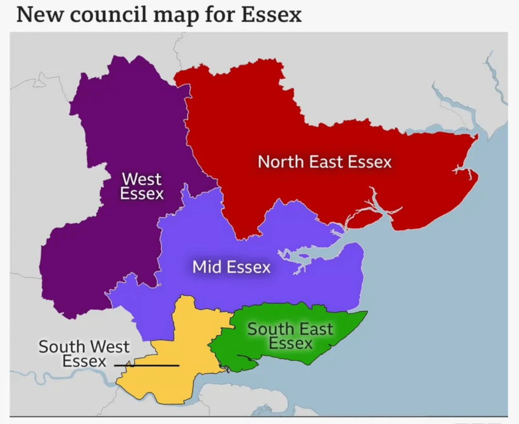
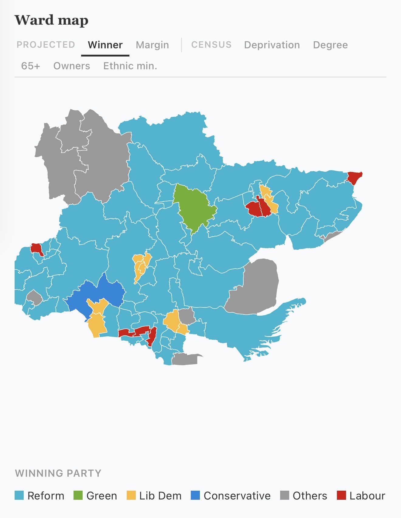
The Gods have spoken. Communities Secretary Steve Reed came down from Mount Westminster this weekend and proclaimed that 15 councils in Essex will be abolished and replaced with five local authorities. I was surprised that UK Gov had not gone with the three unitary authority model proposed by Essex County Council, which seemed to be the only one that fit the government brief.
The five authority model was the one favoured by most existing authorities and does not centralise powers as much as the three model. It is still a centralisation however and decision making will move further away from the people it affects, while the case that the reorganisation will save money is surely weakened by choosing to have five rather than three.
The Dengie will be in the ‘Mid Essex’ unitary – an authority that will stretch from the Greater London boundary to the North Sea coast. It seems likely that the seat of power will be in the City of Chelmsford. It’s the only city in the region, it’s fairly central geographically and it has the buildings and staff of the doomed Essex County Council to draw on, making a transition easier. For similar reasons, I imagine that Chelmsford will also be the seat of the Greater Essex Mayoral Authority when an Essex Mayor is elected in May 2028.
(this all presupposes that a General Election doesn’t happen before local government reorganisation and the Mayoral election and that the next government doesn’t cancel the whole thing as a Starmer folly. Reform UK leader Nigel Farage has said he is “deeply sceptical” about changes to local councils in Essex, “I think that to maintain overall the presence of an identifiable county council is the right way to go” and that Reform UK would try to put a stop to local government reform).
Design and Climate Change section of the Maldon District Local Development Plan
For the Dengie, a move of powers from Maldon to Chelmsford means authority moving from a town it abuts to one that is further away. It’s unclear what value strategies developed at Maldon District level will have when Maldon District is no more – not least the Maldon District Local Development Plan 2014-2029 (reviewed Feb 2025), more recent Neighbourhood Plans across the district that are constrained by the LDP, and the Maldon District Council’s Climate Strategy and Action Plan [pdf].
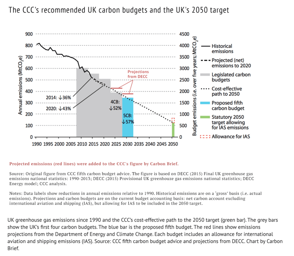
We are entering a crucial period for achieving the UK’s legally binding target of net zero greenhouse gas emissions by 2050 and the interim target of a 58% reduction by the period 2028-2032.
This uncertainty at District level is multiplied at County level. Essex County Council, under a Conservative Party administration, has developed a raft of climate and environment strategies and policies which say a lot of the right things, even though delivery has often been frustratingly slow.
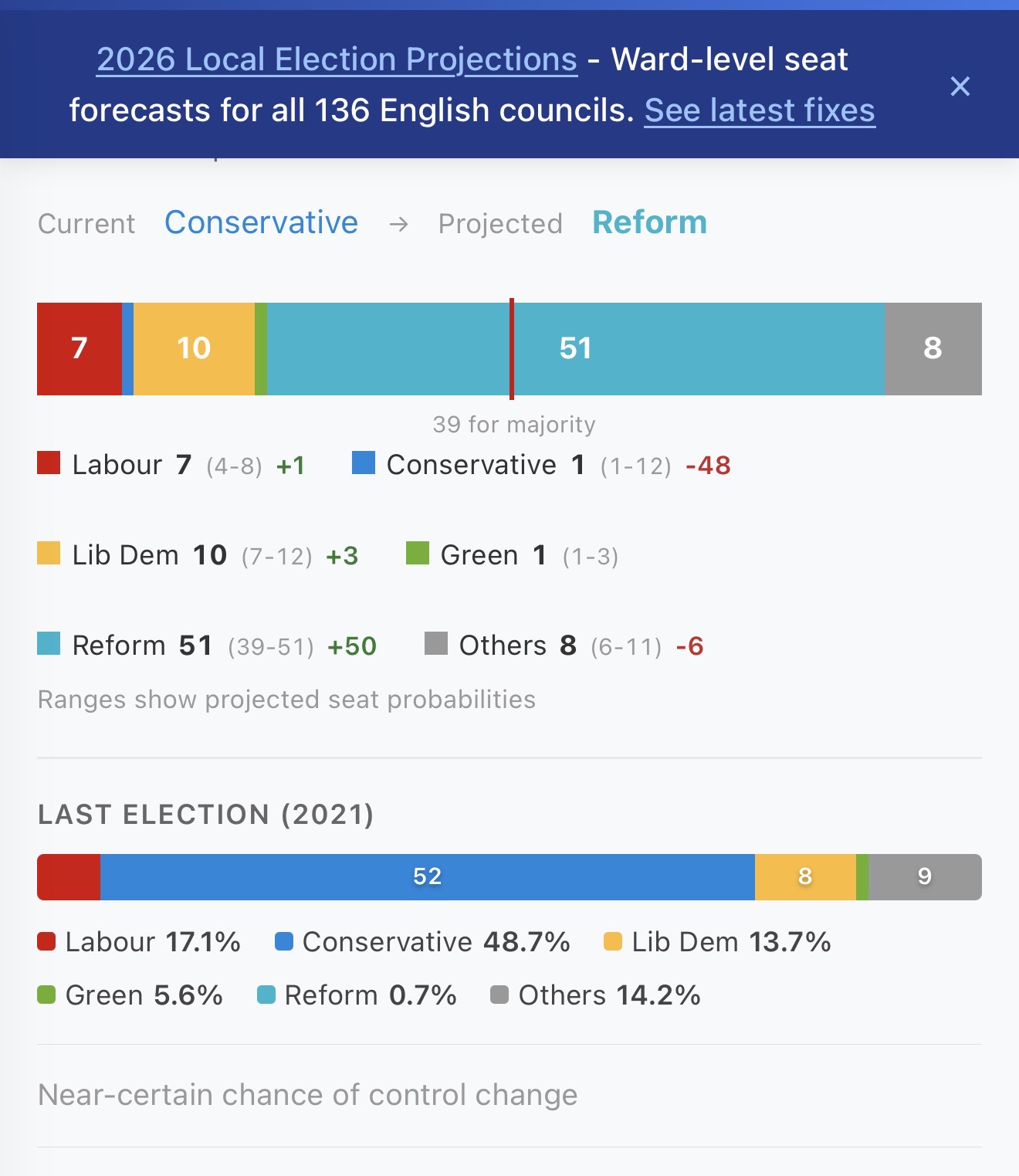
That lack of speed may prove fatal if the political character of the local authorities changes to one less enamoured of net-zero and climate goals. The current polling is therefore sobering.
With a few weeks to go, the Conservatives look set to be wiped out at the May County Council elections. Even the low end of projections for Reform UK would give them majority control in Essex. Conservative Party ‘Climate Czar’ Councillor Peter Schwier is one of those who looks set to lose his seat to Reform UK.
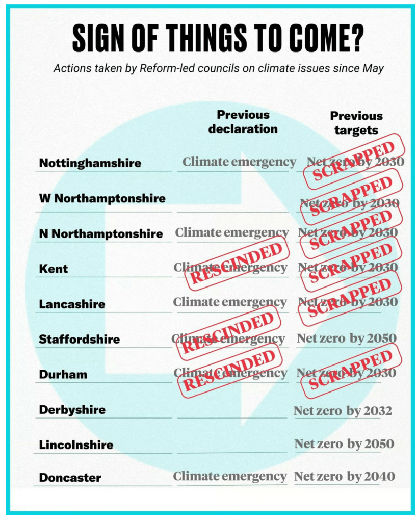
What happened across the Thames at Kent County Council (KCC) when Reform UK took control is a guide as to what to expect: the party initiated sweeping reversals of previous climate commitments.
• Reform UK councillors rescinded KCC’s 2019 Climate Emergency Declaration • The Reform-led council removed Net Zero/carbon neutrality targets and abandoned efforts to meet those targets previously set by the council. • Background information provided by the Reform UK group said the council’s 2019 climate emergency declaration had “endorsed the unproven view of anthropogenic (human-induced) climate change” [pdf]. • They cancelled £32 million of renewable energy property modifications. • They cancelled £7.5 million of electric vehicle transition plans • They voted down motions aimed at supporting the recovery and growth of wildlife and biodiversity by reducing harmful pesticides – despite environmental and public‑health concerns. • Reform UK councillor Chris Hespe called anthropogenic global warming a “hoax”. • Reform UK councillor David Wimble shared a Facebook post highlighting a “Climate Catastrophe Hoax”, where “the climate apocalypse narrative is exaggerated, wrong, and built on fear rather than fact” • Seven out of ten Reform UK controlled councils have scrapped their climate targets since being elected • Academic analysis from the Grantham Research Institute (LSE) found that Reform‑run councils “removed content about climate change from strategy documents” after taking control. KCC is explicitly listed among the councils where Reform UK councillors expressed climate‑science denial and participated in these removals [pdf].
Strategies and policies are much easier to reverse than already existing actions on the ground. I can’t help but think that much of the last decade was wasted and all the pretty pdfs and consultations produced are now dead in the water. Essex should have taken direct control of buses and integrated public transport ticketing and timetables, planning authorities should have demanded net-zero, low bills, homes with domestic energy generation, rain/grey water recycling and minimum 30% on-site biodiversity net gain, the county should be laced with segregated walk/wheel/cycle paths breaking car dependency and improving health outcomes, money spent on waste incinerators should have been burned creating a circular economy instead, our anchor institutions should have collaborated and built community wealth via local procurement led by the public authorities.
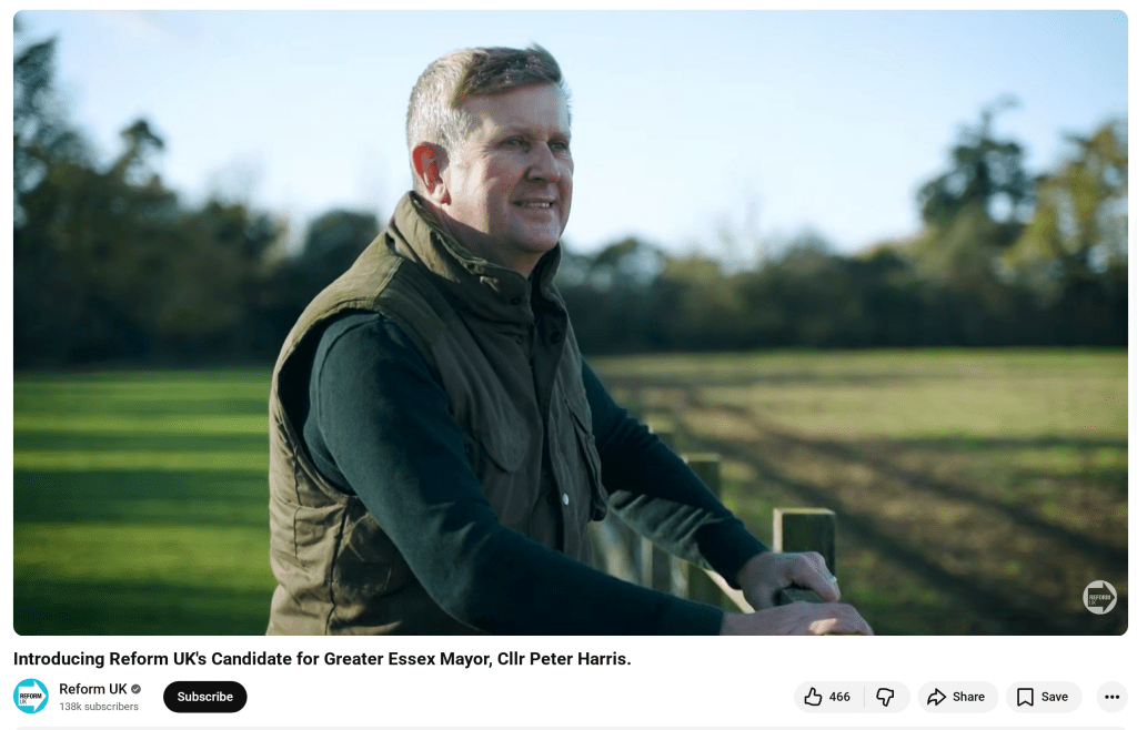
Peter Harris, the Reform UK mayoral candidate for Essex, hasn’t yet made any statements specifically about environmental issues such as climate change, net‑zero, renewable energy, pollution, or biodiversity. He has mentioned ‘protecting our green spaces’ as part of a very general policy agenda, but there’s no detail on what this means in practice.
His promo video has him stood in some fields and his comments there seem to position the ‘green spaces’ protection as being about housing developments rather than nature recovery or habitat protection.
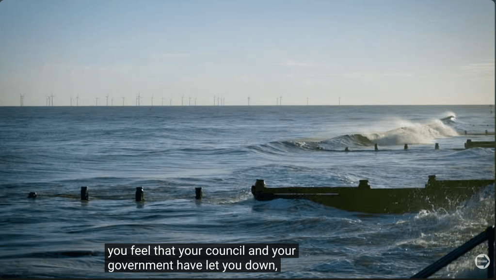
There’s a brief shot of the tide coming in on the Essex coast with the Gunfleet Sands Offshore Wind Farm visible in the distance – but there’s no mention of sea-level rise or renewable energy. Over this image, Harris is talking about the council and the government ‘letting you down’ – is the tide and the wind farm relevant to this, or just B-roll? Hard to tell.
Dr David BullNigel Farage stand-up set at the Circus Tavern
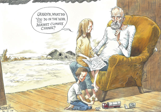
With the Earth’s climate further out of balance than at any time in recorded history, the crash in wildlife populations constituting an extinction event, and human activities increasingly disrupting the natural equilibrium, creating consequences for hundreds and thousands of years, the return of climate change denialism is a bitter pill to swallow.
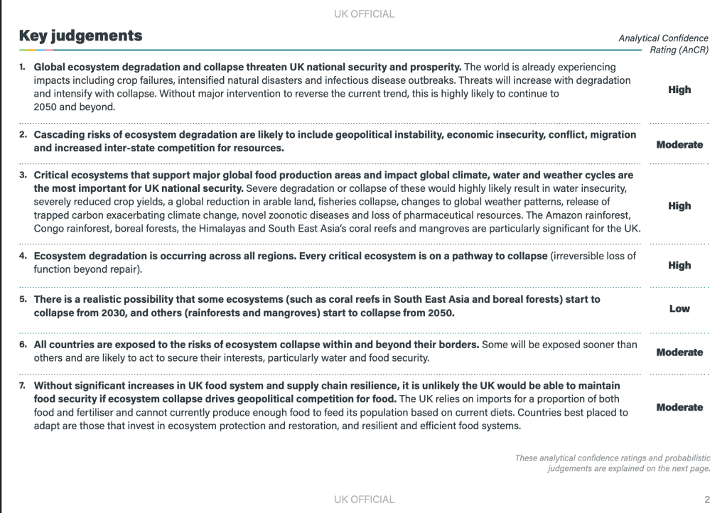
This week The Timesreported that it had seen a document called ‘Status of Defra’s critical systems to 2030 and beyond’, commissioned before the 2024 election by civil servants at the Department for Environment, Farming and Rural Affairs (Defra).
Tasked with identifying looming threats to the underpinnings of modern life, its authors in the Defra Futures team, an expert group of civil servants, concluded that not only Britain’s food supply but also its water supply and international trade networks were “almost certain” to be “on a decline and collapse trajectory”, meaning there was “a realistic possibility that by 2030 (increasing to 2050) our food, water and natural ecosystems (etc) are at strategic risk of catastrophic failure”.’
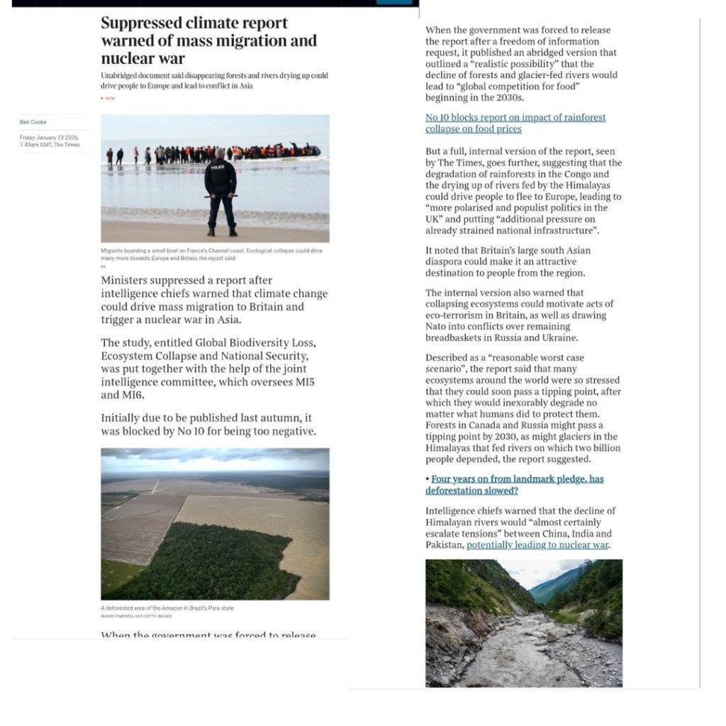
The Government denies a document with this name exists, but a couple of months previously, The Timesreported on a different study ‘Global Biodiversity Loss, Ecosystem Collapse and National Security‘ put together by the joint intelligence committee (which oversees MI5 and MI6). Due to be published last Autumn, it was suppressed until an FOI request produced an abridged version.
From the abridged ‘Global Biodiversity Loss, Ecosystem Collapse and National Security’
The Times reports that it has seen the unabridged version which paints an even gloomier picture of how climate change might affect the UK: driving mass migration from parts of the world made uninhabitable, provoking wars and acts of terror, and creating a global competition for food.
It looks like those of us working to address the climate and ecological emergencies are about to encounter a hostile political environment. When I directed my energies into working with a local climate action group (which was encouraged into existence by the local district council), I did so because I saw opportunities for genuine positive change afforded by the commitments and strategies agreed at political levels from the national to the parish. If, and when, those commitments are abandoned, those strategies are shredded, targets are scrapped, and actions to address the climate and ecological emergencies are ditched – the way forward is unclear. These are the conditions that often produce climate despair and depression, a fatalistic surrender to personal consumption and hedonism, or moves towards more confrontational approaches and direct action.
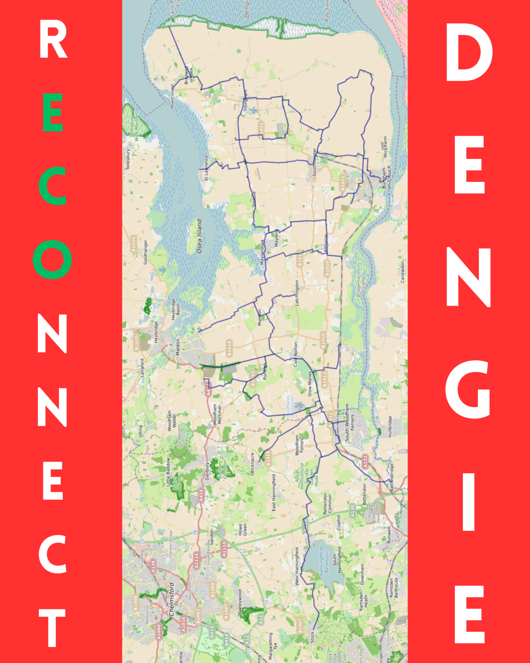
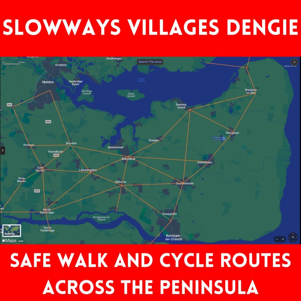
The recent and successive cycle strategy documents from Essex and Maldon have failed to suggest what cycle routes on the Dengie could look like – so, I’ve had a go…
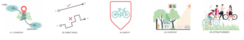
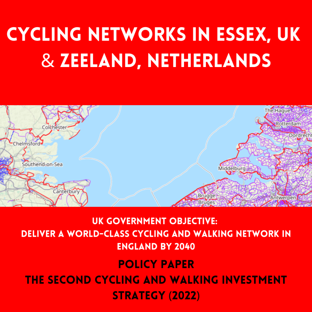
[I should start by stating that the ideal situation would be a Dutch style network, including completely new cycleways taking the most direct line between settlements. This is the only option that would achieve the aim to ‘deliver a world-class cycling and walking network in England by 2040’ expressed in ‘The second cycling and walking investment strategy (CWIS2)’ published under the 2019 to 2022 Johnson Conservative government.
The Dutch CROW Design Manual for Bicycle Traffic considers five basic design principles for network design: Cohesion, Directness, Safety, Comfort and Attractiveness
Despite this being the only option that would meet the national objective, if we place it at one end of an excellent-to-useless-spectrum, then the other end is no-change and cyclists left to fend for themselves on the existing road network. (A bit of signage and some lines painted on the road would be barely better.)
I’ve started with the rECOnnect Dengie aim that every settlement on the peninsula should be connected with a safe active travel route. Railway station and ferry routes should be connected to the network.
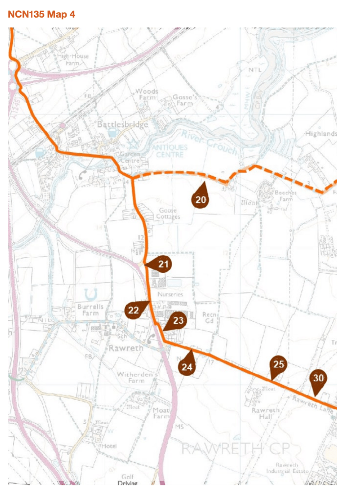
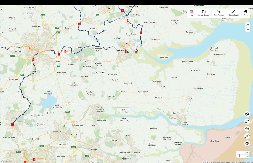
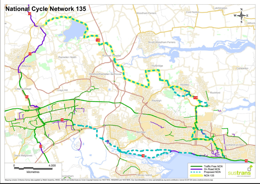
I’ve also looked for how Dengie routes could be connected both to the urban cycle networks in Maldon town and South Woodham Ferrers, and to the National Cycle Network (with connections to NCN 1 at Maldon, NCN 13 at Stock, and the proposed NCN 135 [pdf] at Battlesbridge.
Existing National Cycle Network routesProposed National Cycle Network route |(NCN 135]
I began with using the few bridleways and byways we have, but we don’t have many of them.
We have a better footpath network, and footpaths can be awarded ‘higher rights’ (e.g. use by bicycles) so I’ve tried to fill gaps with them but this still leaves a lot missing.
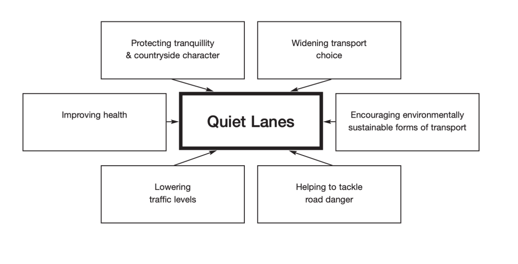
Maldon District currently has no roads designated with Quiet Lane status but I then proceeded to use roads which I think would be appropriate for such a status (avoiding the ‘priority’ PR1 and PR2 roads). Quiet Lane status should being slower speed limits and traffic calming infrastructure.
This still doesn’t provide a network that meets the objective of connecting every settlement, so I’ve then proposed sections over land that currently has no public rights of way (PROW). This will always be controversial and argued over – but cannot be avoided. Here I have prioritised old railway alignments, solar/wind farm access roads and existing farm tracks.
This still leaves some things unaddressed – Latchingdon, for example, is hard to link into a network using existing PROW and avoiding ‘priority roads’; Similarly, connecting North Fambridge and Althorne, other than by the indirect seawall route – bolder plans are necessary here.
The map in the first image is purposely large-scale to avoid instant arguments over routes but I’m happy to share more detailed mapping with anyone who wants to get involved with planning and proposing a network. More local knowledge would certainly improve the routing.