
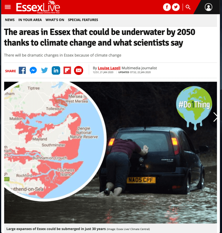
 This week Essex Live brought back the Climate Central Flood Map story that featured in the last post. This time around the story, and its associated maps, were accompanied by some welcome discussion of the implications and possible mitigation from Drs Natalie Hicks and Tom Cameron of the University of Essex’s School of Life Sciences. There was something of a disjunct between their commentary and the featured statements from the Environment Agency and Essex County Council. If local journalism wasn’t in such an under-resourced state that disjunct might have been creatively opened further in order to plot some better sense of the different visions of the future each presents.
The official future remains: ‘we must continue investing in our flood and coastal defences whilst also ensuring that our homes, businesses and infrastructure are resilient to the increasing risks that climate change will bring.’ (Environment Agency). The details are left for discovery within an oblique, almost impenetrable, layering of multi-agency plans and strategies for coastal decision making/shoreline management/flood risk management/coastal erosion risk management all of which have non-conterminous scopes as well as varying update cycles, version control, and download locations. What you don’t tend to find much of, is an acknowledgement of the limitations of the ‘hard’ approach nor an admission that defences will fail. Dr Natalie Hicks, on the other hand, writes that:
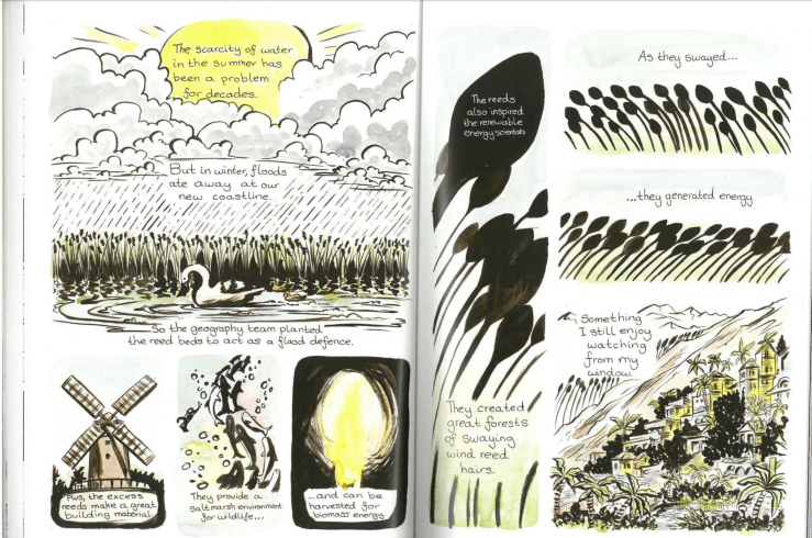
‘I think the very minimum we’d expect is more frequent, more intense and more unpredictable storms, with associated risks of storm surges and coastal flooding. In some cases, this may well be extreme with coastal properties being flooded, and potential loss of coastal habitats. As well as taking steps to reduce CO2 emissions, we do need to examine our coastline and ascertain how best to mitigate these effects, most likely through a combined ‘ hard’ defence such as sea walls, and re-establishing saltmarsh habitats, which provide us with a physical buffer from the sea and the added benefit of a carbon sink.’
Similarly, Dr Tom Cameron remarks that ‘we should be under no illusion, the sea level is rising and it will affect homes and livelihoods of those that live on coasts and former low lying wetlands.’ and that responding to this will require ‘working better with nature’ and a strategy that is more than hard engineering. He mentions Essex University’s research into how saltmarshes act as an interface and buffer zone from the sea
Elsewhere, the quotations from Tom Cameron are a bit incoherent, and some other details are misleading, in a way that makes one long for the sub-editor to get involved. Did he really say this?:
‘A lot of land on this map and the Essex sites including somewhere like Southend were stolen from the coastal sea. It didn’t used to be farm land and where the houses were used to be Saltmarsh.’
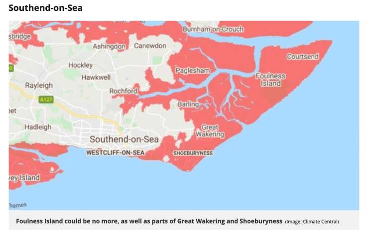
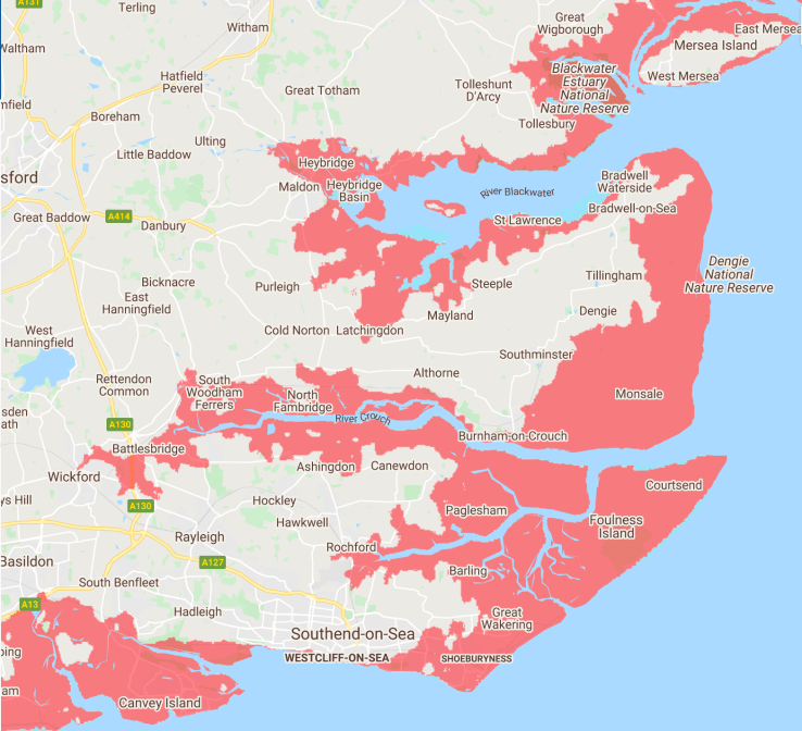
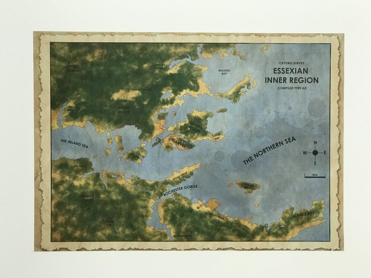
Skirting over the use of language, Southend is largely on high-ground with a cliff frontage to the Estuary – something the same article noted earlier and is indicated on the shared map which reveals that it’s actually Thorpe Bay and Shoeburyness that are at risk on that stretch of coast. Essex certainly does have it’s share of land ‘stolen from the coastal sea’ though – something which is revealed with greater clarity when also looking at the Essex Archipelago, the Dengie peninsula and Canvey Island
Yesterday I went to Southend to catch David Blandy’s exhibition The World After at the Focal Point Gallery. The World After, a film, installation and role-playing game, imagined a post-Anthropocene world 8,000 years after the ecological crisis and sited that exploration in the deep future of Canvey Island. Blandy presented the Island’s history through its reclamation from the sea in the 1600s, submergence in the ’53 floods, and becoming the location of an oil refinery thwarted by the ’73 OPEC crisis and then extended it onwards along a timeline stretching from the present to 10000CE. The installation came with maps.
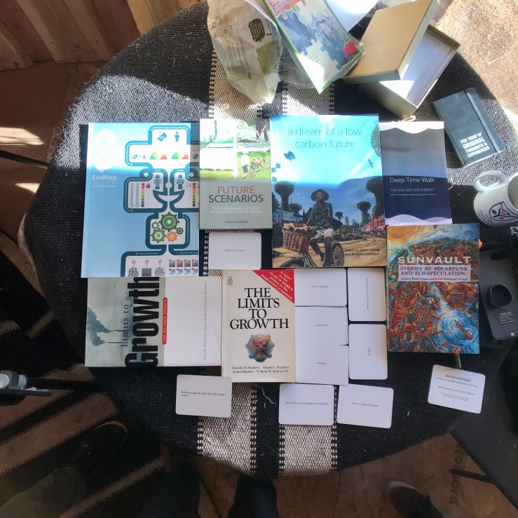
Despite beginning from a more dystopian position, The World After reminded me a lot of A Dream of a Low-Carbon Future, the graphic novel(s) project which formed one outcome of the University of Leed’s Doctoral Training Centre in Low Carbon Technologies.
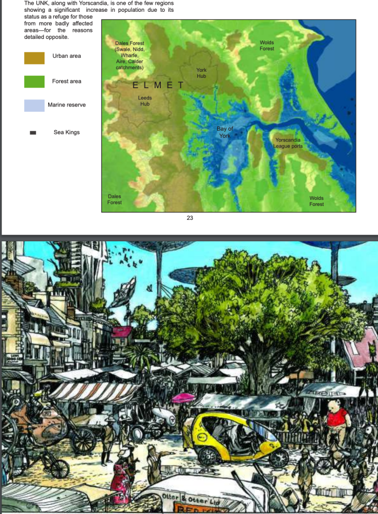
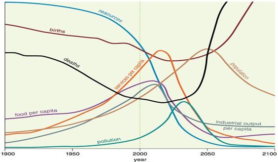
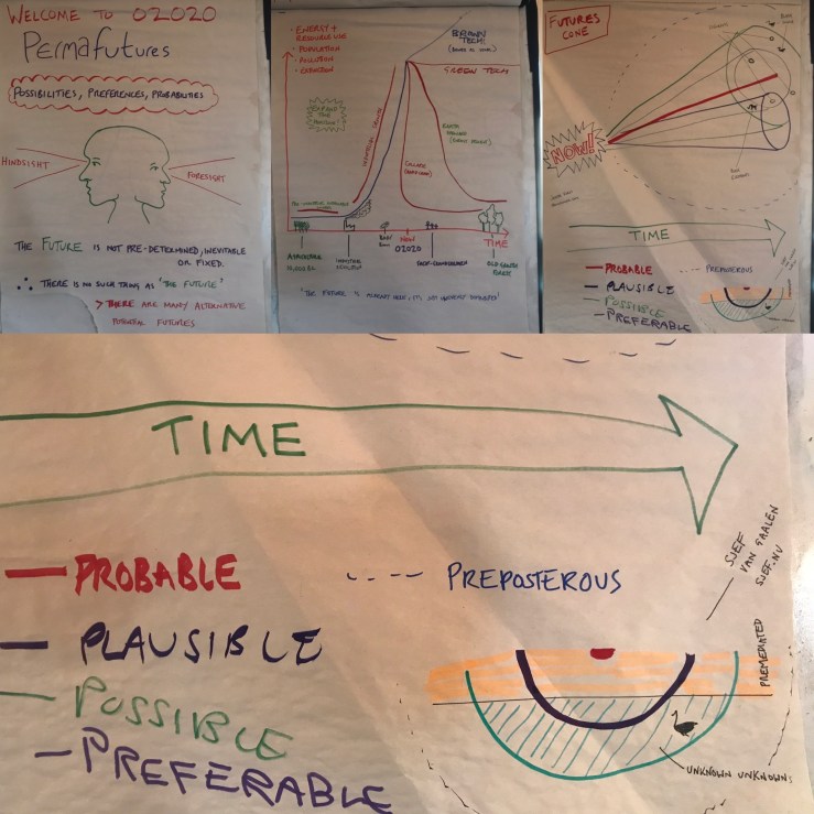
The 2016 graphic novel, with its mix of permaculture, bioregional and solarpunk features, has become part of the library for the Permaculture Design Courses I teach with Graham Burnett of Spiralseed. It comes out when we talk about futures and 4D design. This year that session happened in January, allowing the Roman god Janus to be invoked in service of both hindsight and foresight. It also occurred in the first month of 2020, the year in which some forecasters have stated that the “standard run” (or business-as-usual, BAU) scenario in The Limits to Growth will see the beginning of human decline. The next time we teach futures thinking The World After; Roleplaying Post-humanity as they forge a new world after the climate cataclysm will join the library.
After the exhibition, I headed up to the local history section of Southend Library and continued with some of the research I’m currently doing about Burnham-on-Crouch. Along the way I found this RAF aerial photograph of the Essex Archipelago during the ’53 flood which shows some of the submerged land, the marsh taken back by the water:
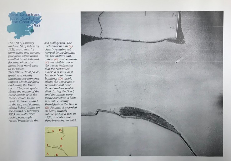
We’re a few days off the 80th anniversary of the ’53 flood now, 80 years on from the last ‘one in a hundred years’ flood (=1% chance in any given year) – a folk statistic that predates the predictions of sea-level rise and the wilder weather produced by more heat in the oceans. (BTW I’m looking forward to Lucia Dove’s Floodlines on the ’53 floods from an Essex/Netherlands perspective).
Public imagination remains very far from any reaction to this past “build the dykes higher”, but on Twitter I saw a more interesting reaction from Jim Pullen, who was involved with the managed retreat at Tollesbury, hinting half-in-jest that this coastal crisis was an opportunity to return to the ‘proper’ strandline.
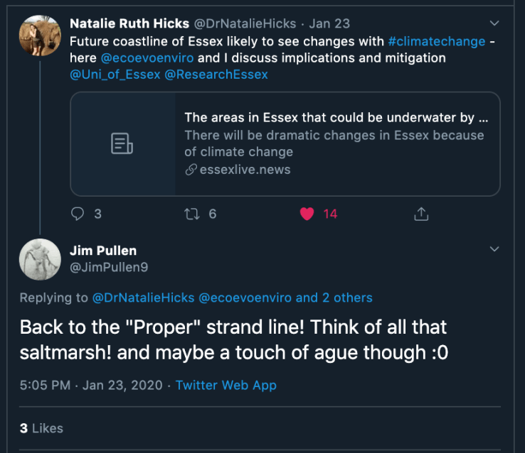
I interpret his ‘proper’ as self-willed and I was reminded of the lines from Anticipatory History on managed realignment that I quoted in Managed Retreat #1:
‘the terminology might stink… but the possibilities of life without boundaries are revolutionary’

Reblogged this on and commented:
Given that a fair sized chunk of the region we cover is potentially at risk from coastal flooding, this is an interesting contribution to the debate on what can and should be done…
LikeLike